활용사례
| 제목 | A Feasibility Study of Sea Ice Motion and Deformation Measurements Using Multi-Sensor High-Resolution Optical Satellite Images | ||
|---|---|---|---|
| 국/내외 | 국외 | 작성일 | 2017-09-28 |
|
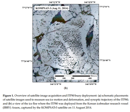
Sea ice motion and deformation have generally been measured using low-resolution passive microwave or mid-resolution radar remote sensing datasets of daily (or few days) intervals to monitor long-term trends over a wide polar area. This feasibility study presents an application of high-resolution optical images from operational satellites, which have become more available in polar regions, for sea ice motion and deformation measurements. The sea ice motion, i.e., Lagrangian vector, is measured by using a maximum cross-correlation (MCC) technique and multi-temporal high-resolution images acquired on 14–15 August 2014 from multiple spaceborne sensors on board Korea Multi-Purpose Satellites (KOMPSATs) with short acquisition time intervals. The sea ice motion extracted from the six image pairs of the spatial resolutions were resampled to 4 m and 15 m yields with vector length measurements of 57.7 m root mean square error (RMSE) and −11.4 m bias and 60.7 m RMSE and −13.5 m bias, respectively, compared with buoy location records. The errors from both resolutions indicate more accurate measurements than from conventional sea ice motion datasets from passive microwave and radar data in ice and water mixed surface conditions. In the results of sea ice deformation caused by interaction of individual ice floes, while free drift patterns of ice floes were delineated from the 4 m spatial resolution images, the deformation was less revealing in the 15 m spatial resolution image pairs due to emphasized discretization uncertainty from coarser pixel sizes. The results demonstrate that using multi-temporal high-resolution optical satellite images enabled precise image block matching in the melting season, thus this approach could be used for expanding sea ice motion and deformation dataset, with an advantage of frequent image acquisition capability in multiple areas by means of many operational satellites. |
|||
| 출처 | Remote Sensing | ||
연관위성영상
-
 미국:자유의 여신상(2023-11-03)
2023-11-14
-
 리비아:데르나 홍수(2023-09-13)
2023-09-18
-
 스페인:홍수(2023-09-06)
2023-09-14
연관활용사례
-
항공영상을 이용한 다목적실용위...
지리
2024-04-24
-
KOMPSAT-3/3A 영상으...
토양
2024-04-19
-
SSResUnet 모델을 이용...
토양
2024-04-19
연관미디어
-
항우연
천리안위성 2A호, 스마...
2019-07-25
-
항우연
천리안위성 2A호가 최초...
2019-02-07

네팔:지진(2015-05-05)
| 카테고리 | 재난재해 |
|---|---|
| 위성정보 | KOMPSAT-3 |
| 생성일 | 2015-03-24 |
세부정보
| ProductID | K3_20150505073608_15817_06161210 |
|---|---|
| 국가(영문) | Nepal |
| 국가 | 네팔 |
| 지역 | Pokhara |
| 레벨 | 1R |