활용사례
| 제목 | Developing a predictive environment-based model for mapping biological soil crust patterns at the local scale in the Sahel | ||
|---|---|---|---|
| 국/내외 | 국외 | 작성일 | 2018-01-12 |
|
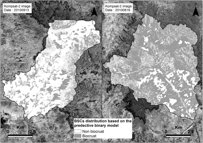
Several studies have demonstrated the great range of possibilities offered by remote sensing in identifying, estimating and mapping biological soil crust (BSC) patterns, i.e. a feature recognised to play major functions in drylands. However those techniques are suitable mainly where BSC patterns are abundant (> 30%) and vegetation cover low (< 10%), otherwise reflectance values matched different levels of BSCs mixed with vegetation and bare soil surfaces. |
|||
| 출처 | CATENA | ||
| 이전글 | 교차융합영상을 이용한 S²CVA 기법의 적용 |
|---|---|
| 다음글 | ITPCA 기반의 무감독 변화탐지 기법을 이용한 산림황폐화 분석 |
연관위성영상
-
 미국:자유의 여신상(2023-11-03)
2023-11-14
-
 리비아:데르나 홍수(2023-09-13)
2023-09-18
-
 스페인:홍수(2023-09-06)
2023-09-14
연관활용사례
-
KOMPSAT-3/3A 영상으...
토양
2024-04-19
-
SSResUnet 모델을 이용...
토양
2024-04-19
-
KOMPSAT-3/3A 영상으...
환경
2024-04-16
연관미디어
-
항우연
천리안위성 2A호, 스마...
2019-07-25
-
항우연
천리안위성 2A호가 최초...
2019-02-07

네팔:지진(2015-05-05)
| 카테고리 | 재난재해 |
|---|---|
| 위성정보 | KOMPSAT-3 |
| 생성일 | 2015-03-24 |
세부정보
| ProductID | K3_20150505073608_15817_06161210 |
|---|---|
| 국가(영문) | Nepal |
| 국가 | 네팔 |
| 지역 | Pokhara |
| 레벨 | 1R |