활용사례
| 제목 | International Charter: Flood in Venezuela | ||
|---|---|---|---|
| 국/내외 | 국외 | 작성일 | 2018-09-05 |
|
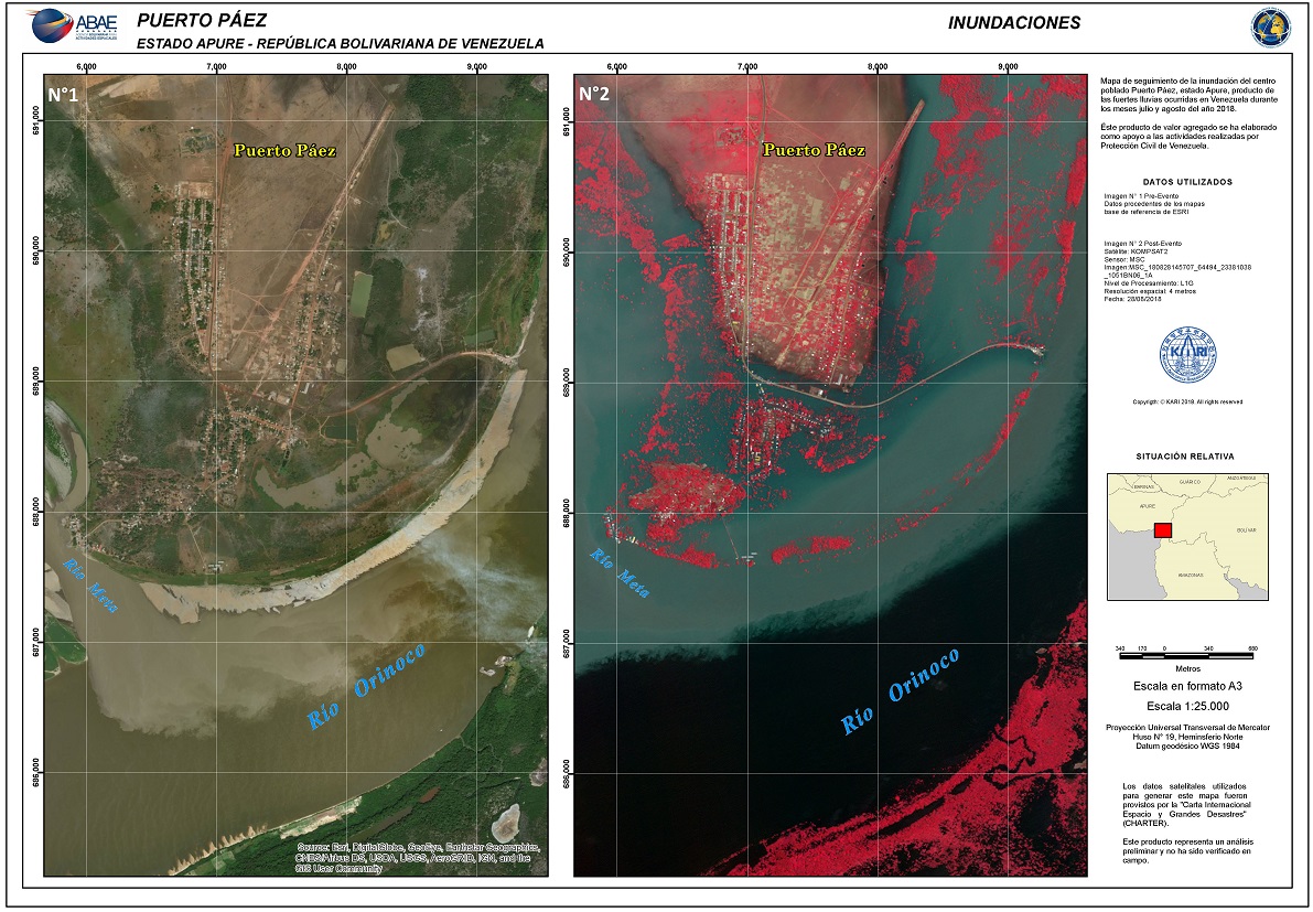
Persistent heavy rains have caused severe flooding in the Venezuelan provinces of Amazonas, Apure, Bolivar and Anzoategui. Over 10,000 people have been affected, with 36 sectors in the province on a red alert defined by the Venezuelan Civil Protection. |
|||
| 출처 | International Charter | ||
| 이전글 | 고해상도 광학 인공위성 영상을 활용한 선박탐지 방법 |
|---|---|
| 다음글 | Seasonal and Look-directional Variation of X-band SAR Sigma Nought in Mongolian Land Surface |
연관위성영상
-
 스페인:홍수(2023-09-06)
2023-09-14
-
 인도:바갈푸르 홍수(2023-08-29)
2023-10-23
-
 이탈리아:체세나 홍수(2023-05-23)
2023-06-08
연관활용사례
-
Wildfire in Chile
재해
2024-04-04
-
Flooding in Chile
재해
2023-08-17
-
Flash Floods in ...
재해
2023-08-17
최신미디어
-
항우연
항우연, 심우주탐사를 위...
2024-03-14
-
항우연
대한민국 최초 달 궤도선...
2024-03-14

네팔:지진(2015-05-05)
| 카테고리 | 재난재해 |
|---|---|
| 위성정보 | KOMPSAT-3 |
| 생성일 | 2015-03-24 |
세부정보
| ProductID | K3_20150505073608_15817_06161210 |
|---|---|
| 국가(영문) | Nepal |
| 국가 | 네팔 |
| 지역 | Pokhara |
| 레벨 | 1R |