활용사례
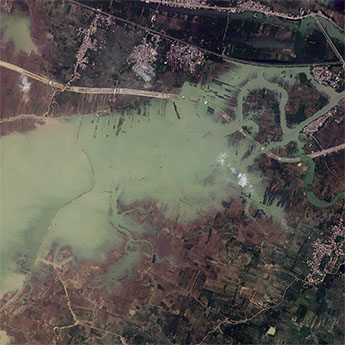
| 제목 | International Charter: Flood in India | ||
|---|---|---|---|
| 국/내외 | 국외 | 작성일 | 2019-07-23 |
|
Heavy rainfall caused severe flooding across India, with the states of Assam, Bihar and Uttar Pradesh being badly affected. At least 55 people are reported to have been killed and flood waters have affected over 2.5 million people. |
|||
| 출처 | International Charter | ||

| 이전글 | 전이학습과 딥러닝 네트워크를 활용한 고해상도 위성영상의 변화탐지 |
|---|---|
| 다음글 | 다수 이동체간 동기화 및 항공우주 데이터 처리 기술 연구 |
연관위성영상
-
 스페인:홍수(2023-09-06)
2023-09-14
-
 인도:바갈푸르 홍수(2023-08-29)
2023-10-23
-
 인도:염전(2023-06-09)
2023-07-11
연관활용사례
-
Wildfire in Chile
재해
2024-04-04
-
Flooding in Chile
재해
2023-08-17
-
Flash Floods in ...
재해
2023-08-17
최신미디어
-
항우연
항우연, 심우주탐사를 위...
2024-03-14
-
항우연
대한민국 최초 달 궤도선...
2024-03-14

네팔:지진(2015-05-05)
| 카테고리 | 재난재해 |
|---|---|
| 위성정보 | KOMPSAT-3 |
| 생성일 | 2015-03-24 |
세부정보
| ProductID | K3_20150505073608_15817_06161210 |
|---|---|
| 국가(영문) | Nepal |
| 국가 | 네팔 |
| 지역 | Pokhara |
| 레벨 | 1R |