활용사례
| 제목 | Iterative Trimming Algorithm을 이용하여 자동추출된 KOMPSAT-3A 훈련자료 신뢰성 평가 | ||
|---|---|---|---|
| 국/내외 | 국내 | 작성일 | 2020-02-07 |
|
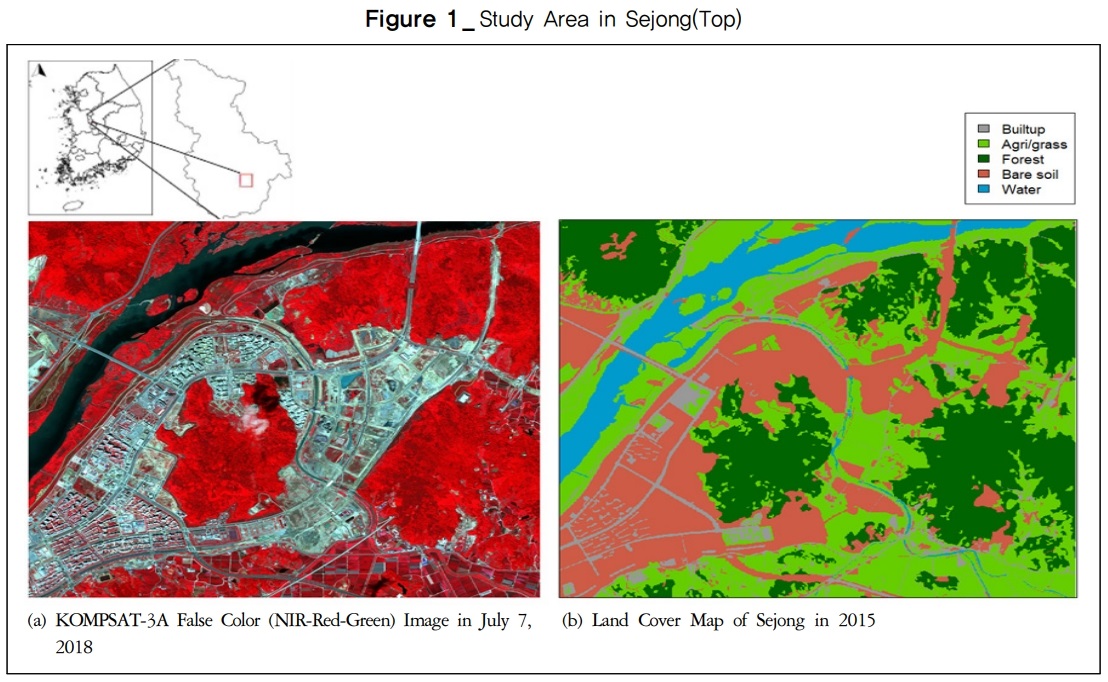
Image classification is one of the key issues of remote sensing technology and selecting training data is an essential process in supervised image classification. Dramatically increasing imagery data require more effective and automated classification techniques. The traditional process of selecting training data requires intensive manpower and, as a result, it has been costly and time-consuming. This study proposed an automatic training data extraction technique using outdated geographic information system (GIS) data and its applicability was tested. We used a high-resolution KOMPSAT-3A satellite image taken on July 7, 2018, and the land cover map in 2015 for the test of automated training data extraction based on the iterative trimming algorithm. First, the training data were extracted based on the polygon of the land cover map. Then, the probability distributions of each land cover class were estimated using kernel density estimation. The outliers were removed in the order of low probability. The bootstrap technique was used to determine the ratio of removing outliers. The ratios were different among the land cover classes. The removing ratio was 0.08 for the urbanized area, 0.16 for agriculture/land, 0.04 for forests, 0.16 for bare soil and 0.04 for water. With the refined training data, image classification was conducted. This approach allows automatic extraction of training data based on GIS data without manual digitizing. It is expected to contribute to an automatic and timely update of the urban land cover map with high-resolution imagery. |
|||
| 출처 | 국토연구 | ||
| 이전글 | KOMPSAT-5 위성 영상을 활용한 라오스 세피안-세남노이 댐 붕괴에 따른 수계변화 탐지 |
|---|---|
| 다음글 | Oil Spill Mapping from Kompsat-2 High-Resolution Image Using Directional Median Filtering and Artificial Neural Network |
연관위성영상
-
 미국:자유의 여신상(2023-11-03)
2023-11-14
-
 리비아:데르나 홍수(2023-09-13)
2023-09-18
-
 스페인:홍수(2023-09-06)
2023-09-14
연관활용사례
-
항공영상을 이용한 다목적실용위...
지리
2024-04-24
-
KOMPSAT-3/3A 영상으...
토양
2024-04-19
-
SSResUnet 모델을 이용...
토양
2024-04-19
최신미디어
-
과기정통부
초소형군집위성 1호 발사...
2024-04-24
-
항우연
항우연, 심우주탐사를 위...
2024-03-14

네팔:지진(2015-05-05)
| 카테고리 | 재난재해 |
|---|---|
| 위성정보 | KOMPSAT-3 |
| 생성일 | 2015-03-24 |
세부정보
| ProductID | K3_20150505073608_15817_06161210 |
|---|---|
| 국가(영문) | Nepal |
| 국가 | 네팔 |
| 지역 | Pokhara |
| 레벨 | 1R |