활용사례
| 제목 | Detection of Wildfire-Damaged Areas Using Kompsat-3: Image A Case of the 2019 Unbong Mountain Fire in Busan, South Korea | ||
|---|---|---|---|
| 국/내외 | 국내 | 작성일 | 2020-03-09 |
|
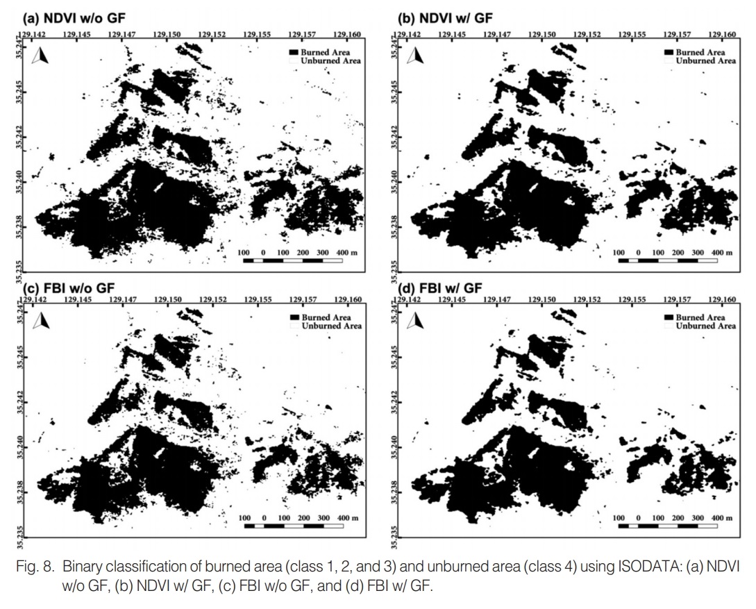
Forest fire is a critical disaster that causes massive destruction of forest ecosystem and economic loss. Hence, accurate estimation of the burned area is important for evaluation of the degree of damage and for preparing baseline data for recovery. Since most of the area size damaged by wildfires in Korea is less than 1 ha, it is necessary to use satellite or drone images with a resolution of less than 10m for detecting the damage area. This paper aims to detect wildfire-damaged area from a Kompsat-3 image using the indices such as NDVI (normalized difference vegetation index) and FBI (fire burn index) and to examine the classification characteristics according to the methods such as Otsu thresholding and ISODATA (iterative self-organizing data analysis technique). To mitigate the salt-and-pepper phenomenon of the pixel-based classification, a gaussian filter was applied to the images of NDVI and FBI. Otsu thresholding and ISODATA could distinguish the burned forest from normal forest appropriately, and the salt-and-pepper phenomenon at the boundaries of burned forest was reduced by the gaussian filter. The result from ISODATA with gaussian filter using NDVI was closest to the official record of damage area (56.9 ha) published by the Korea Forest Service. Unlike Otsu thresholding for binary classification, since the ISODATA categorizes the images into multiple classes such as (1) severely burned area, (2) moderately burned area, (3) mixture of burned and unburned areas, and (4) unburned area, the characteristics of the boundaries consisting of burned and normal forests can be better expressed. It is expected that our approach can be utilized for the high-resolution images obtained from other satellites and drones. |
|||
| 출처 | 대한원격탐사학회지 | ||
| 이전글 | 위성영상 지상위치관측 시스템의 정확도 분석 |
|---|---|
| 다음글 | Fully Convolutional Networks with Multiscale 3D Filters and Transfer Learning for Change Detection in High Spatial Resolution Satellite Images |
연관위성영상
-
 미국:자유의 여신상(2023-11-03)
2023-11-14
-
 리비아:데르나 홍수(2023-09-13)
2023-09-18
-
 스페인:홍수(2023-09-06)
2023-09-14
연관활용사례
-
KOMPSAT-3/3A 영상으...
환경
2024-04-16
-
KOMPSAT-3와 KOMPS...
토양
2024-04-16
-
Wildfire in Chile
재해
2024-04-04
연관미디어
-
항우연
천리안위성 2A호, 스마...
2019-07-25
-
항우연
천리안위성 2A호가 최초...
2019-02-07

네팔:지진(2015-05-05)
| 카테고리 | 재난재해 |
|---|---|
| 위성정보 | KOMPSAT-3 |
| 생성일 | 2015-03-24 |
세부정보
| ProductID | K3_20150505073608_15817_06161210 |
|---|---|
| 국가(영문) | Nepal |
| 국가 | 네팔 |
| 지역 | Pokhara |
| 레벨 | 1R |