활용사례
| 제목 | Mapping Forest Vertical Structure in Jeju Island from Optical and Radar Satellite Images Using Artificial Neural Network | ||
|---|---|---|---|
| 국/내외 | 국내 | 작성일 | 2020-03-26 |
|
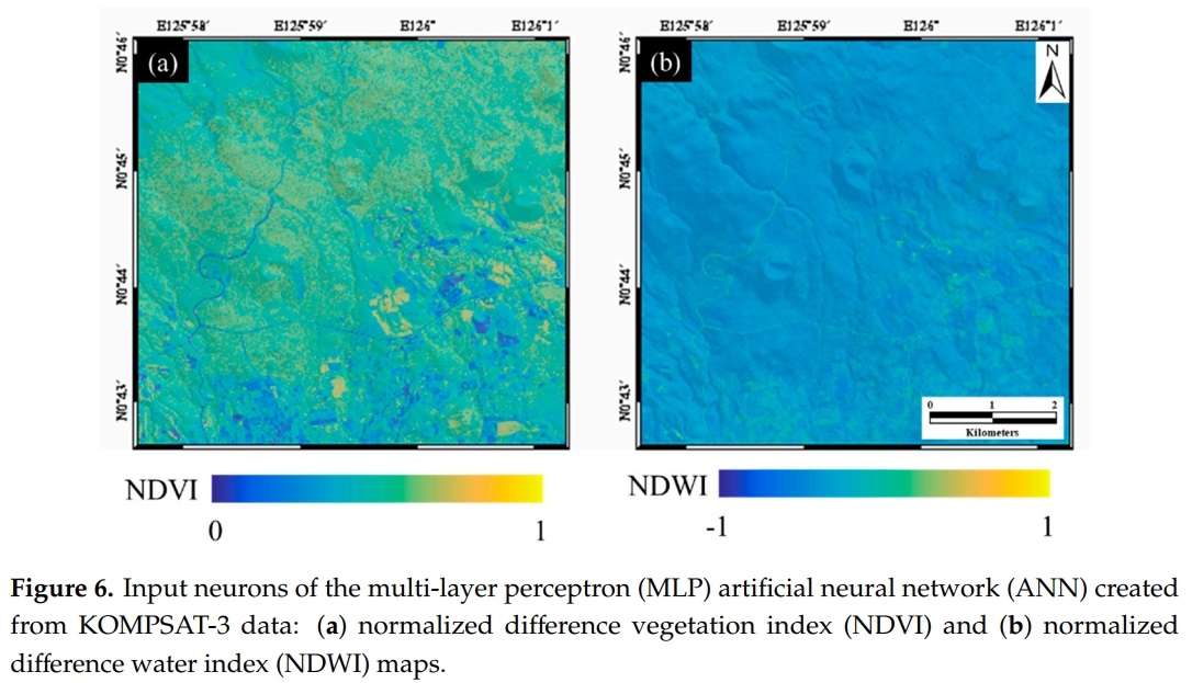
Recently, due to the acceleration of global warming, an accurate understanding and management of forest carbon stocks, such as forest aboveground biomass, has become very important. The vertical structure of the forest, which is the internal structure of the forest, was mainly investigated by field surveys that are labor intensive. Recently, remote sensing techniques have been actively used to explore large and inaccessible areas. In addition, machine learning techniques that could classify and analyze large amounts of data are being used in various fields. Thus, this study aims to analyze the forest vertical structure (number of tree layers) to estimate forest aboveground biomass in Jeju Island from optical and radar satellite images using artificial neural networks (ANN). For this purpose, the eight input neurons of the forest related layers, based on remote sensing data, were prepared: normalized difference vegetation index (NDVI), normalized difference water index (NDWI), NDVI texture, NDWI texture, average canopy height, standard deviation canopy height and two types of coherence maps were created using the Kompsat-3 optical image, L-band ALOS PALSAR-1 radar images, digital surface model (DSM), and digital terrain model (DTM). The forest vertical structure data, based on field surveys, was divided into the training/validation and test data and the hyper-parameters of ANN were trained using the training/validation data. The forest vertical classification result from ANN was evaluated by comparison to the test data. It showed about a 65.7% overall accuracy based on the error matrix. This result shows that the forest vertical structure map can be effectively generated from optical and radar satellite images and existing DEM and DTM using the ANN approach, especially for national scale mapping. |
|||
| 출처 | Remote Sensing | ||
| 이전글 | Fully Convolutional Networks with Multiscale 3D Filters and Transfer Learning for Change Detection in High Spatial Resolution Satellite Images |
|---|---|
| 다음글 | 바누아투 루간빌 지역의 열대 저기압 해럴드 전후 영상 |
연관위성영상
-
 미국:자유의 여신상(2023-11-03)
2023-11-14
-
 리비아:데르나 홍수(2023-09-13)
2023-09-18
-
 스페인:홍수(2023-09-06)
2023-09-14
연관활용사례
-
KOMPSAT-3와 KOMPS...
토양
2024-04-16
-
Wildfire in Chile
재해
2024-04-04
-
KOMPSAT-3/3A 영상 ...
해양
2023-12-04
최신미디어
-
항우연
항우연, 심우주탐사를 위...
2024-03-14
-
항우연
대한민국 최초 달 궤도선...
2024-03-14

네팔:지진(2015-05-05)
| 카테고리 | 재난재해 |
|---|---|
| 위성정보 | KOMPSAT-3 |
| 생성일 | 2015-03-24 |
세부정보
| ProductID | K3_20150505073608_15817_06161210 |
|---|---|
| 국가(영문) | Nepal |
| 국가 | 네팔 |
| 지역 | Pokhara |
| 레벨 | 1R |