활용사례
| 제목 | Study on 1:5,000 map produced using KOMPSAT-3 satellite image | ||
|---|---|---|---|
| 국/내외 | 국외 | 작성일 | 2020-09-09 |
|
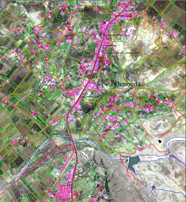
In this study, the process and results of (1) generating an ortho-image using KOMPSAT-3 images and (2) producing a 2D map with a scale of 1:5,000 from the ortho-image using a softcopy photogrammetic workstation were reviewed. The study area is a local city called Khmouda in Caserin province, Tunisia, and KOMPSAT-3 L1O stereo pair images acquired in June 2019 provided by SIIS was used for this study. |
|||
| 출처 | SIIS(SI Imaging Services) | ||
| 이전글 | Change detection by using KOMPSAT-5 InSAR data |
|---|---|
| 다음글 | Planetscope 영상을 이용한 KOMPSAT-3/3A 영상의 기하품질 향상 방안 연구 |
연관위성영상
-
 미국:자유의 여신상(2023-11-03)
2023-11-14
-
 리비아:데르나 홍수(2023-09-13)
2023-09-18
-
 스페인:홍수(2023-09-06)
2023-09-14
연관활용사례
-
KOMPSAT-3/3A 영상으...
토양
2024-04-19
-
SSResUnet 모델을 이용...
토양
2024-04-19
-
KOMPSAT-3/3A 영상으...
환경
2024-04-16
최신미디어
-
과기정통부
초소형군집위성 1호 발사...
2024-04-24
-
항우연
항우연, 심우주탐사를 위...
2024-03-14

네팔:지진(2015-05-05)
| 카테고리 | 재난재해 |
|---|---|
| 위성정보 | KOMPSAT-3 |
| 생성일 | 2015-03-24 |
세부정보
| ProductID | K3_20150505073608_15817_06161210 |
|---|---|
| 국가(영문) | Nepal |
| 국가 | 네팔 |
| 지역 | Pokhara |
| 레벨 | 1R |