활용사례
| 제목 | Performance of Support Vector Machine for Classifying Land Cover in Optical Satellite Images:A Case Study in Delaware River Port Area | ||
|---|---|---|---|
| 국/내외 | 국내 | 작성일 | 2023-02-02 |
|
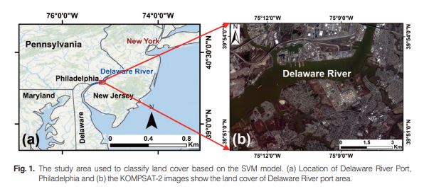
The availability of high-resolution satellite images provides precise information without direct observation of the research target. Korea Multi-Purpose Satellite (KOMPSAT), also known as the Arirang satellite, has been developed and utilized for earth observation. The machine learning model was continuously proven as a good classifier in classifying remotely sensed images. Thisstudy aimed to compare the performance of the support vector machine (SVM) model in classifying the land cover of the Delaware River port area on high and medium-resolution images. Three optical images, which are KOMPSAT-2, KOMPSAT-3A, and Sentinel-2B, were classified into six land cover classes, including water, road, vegetation, building, vacant, and shadow. The KOMPSAT images are provided by Korea Aerospace Research Institute (KARI), and the Sentinel-2B image was provided by the European Space Agency (ESA). The training samples were manually digitized for each land cover class and considered the reference image. The predicted images were compared to the actual data to obtain the accuracy assessment using a confusion matrix analysis. In addition, the timeconsuming training and classifying were recorded to evaluate the model performance. The results showed that the KOMPSAT-3A image has the highest overall accuracy and followed by KOMPSAT-2 and Sentinel-2B results. On the contrary, the model took a long time to classify the higher-resolution image compared to the lower resolution. For that reason, we can conclude that the SVM model performed better in the higher resolution image with the consequence of the longer time-consuming training and classifying data. Thus, this finding might provide consideration for related researchers when selecting satellite imagery for effective and accurate image classification. |
|||
| 출처 | 대한원격탐사학회지 | ||
| 이전글 | KOMPSAT-3·3A 위성영상 글로벌 융합활용을 위한 다중센서 위성영상과의 정밀영상정합 |
|---|---|
| 다음글 | 핵활동 모니터링을 위한 소형객체 비율에 따른 U-Net의 의미론적 분할 성능 비교 |
연관위성영상
-
 미국:자유의 여신상(2023-11-03)
2023-11-14
-
 리비아:데르나 홍수(2023-09-13)
2023-09-18
-
 스페인:홍수(2023-09-06)
2023-09-14
연관활용사례
-
Wildfire in Chile
재해
2024-04-04
-
KOMPSAT-3/3A 영상 ...
해양
2023-12-04
-
다목적실용위성 3A 영상정보의...
지리
2023-11-07
최신미디어
-
항우연
항우연, 심우주탐사를 위...
2024-03-14
-
항우연
대한민국 최초 달 궤도선...
2024-03-14

네팔:지진(2015-05-05)
| 카테고리 | 재난재해 |
|---|---|
| 위성정보 | KOMPSAT-3 |
| 생성일 | 2015-03-24 |
세부정보
| ProductID | K3_20150505073608_15817_06161210 |
|---|---|
| 국가(영문) | Nepal |
| 국가 | 네팔 |
| 지역 | Pokhara |
| 레벨 | 1R |