활용사례
| 제목 | 위성영상을 활용한 생태피복도 작성과 E-GIS DB 구축 | ||
|---|---|---|---|
| 국/내외 | 국내 | 작성일 | 2015-03-23 |
|
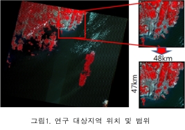
In this research, the ground coverage, the Albedo distribution, moisture content distribution, NDVI distribution of Busan Metropolitan City and the entire Gyeongnam region were calculated with the validation review using satellite images in order to establish Urban Environment & Ecology GIS DB. With Busan Metropolitan City and the entire Gyeongnam being the subjects, the satellite images of 2002 and 2012 were used to create the ground coverage, Albedo, NDVI distribution. The changes in the city development of the past 10 years and the ecological changes were compared and analyzed and by integrating DEM, the geographical information, it was meshed into a unit of 500m x 500m in order to establish one integrated Urban Environment & Ecology GIS DB. |
|||
| 출처 | 대한건축학회 논문집 - 계획계(DBPia 제공) | ||
| 이전글 | 위성영상과 GIS를 이용한 낙동강하구 지형변화탐지 |
|---|---|
| 다음글 | GIS 와 위성영상을 활용한 3차원 문화재 정보 시스템 구현 |
최신위성영상
-
 미국:자유의 여신상(2023-11-03)
2023-11-14
-
 리비아:데르나 홍수(2023-09-13)
2023-09-18
-
 스페인:홍수(2023-09-06)
2023-09-14
연관활용사례
-
항공영상을 이용한 다목적실용위...
지리
2024-04-24
-
다목적실용위성 6호 수신처리시...
지리
2024-04-24
-
KOMPSAT-3/3A 영상으...
토양
2024-04-19
연관미디어
-
항우연
과학기술정보통신부, 국토...
2023-02-13
-
항우연
한국항공우주연구원항우연 ...
2023-01-04

네팔:지진(2015-05-05)
| 카테고리 | 재난재해 |
|---|---|
| 위성정보 | KOMPSAT-3 |
| 생성일 | 2015-03-24 |
세부정보
| ProductID | K3_20150505073608_15817_06161210 |
|---|---|
| 국가(영문) | Nepal |
| 국가 | 네팔 |
| 지역 | Pokhara |
| 레벨 | 1R |