활용사례
| 제목 | Potential of remote sensing in management of tidal flats: A case study of thematic mapping in the Korean tidal flats | ||
|---|---|---|---|
| 국/내외 | 국내 | 작성일 | 2017-06-20 |
|
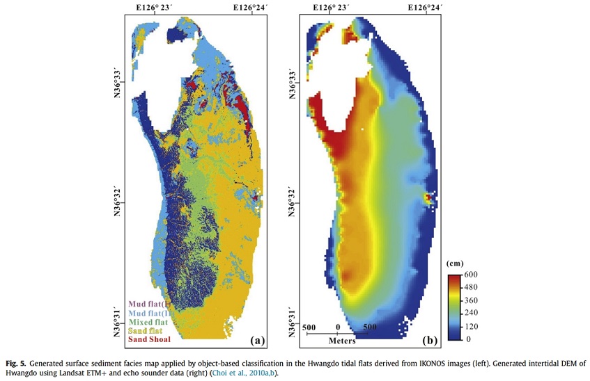
Tidal flats in Korea are increasingly being changed by various construction projects. This report reviews the remote sensing techniques used to monitor tidal flats and suggests appropriate techniques for meeting monitoring targets for the effective management of tidal flats. The application of remote sensing to studies of tidal flats and the characteristics of the preferred satellite data for a particular monitoring target were examined from a statistical analysis of peer-reviewed journals and case studies of Korean tidal flats. Specifically, three different monitoring targets were examined: topography, sedimentary facies, and biofacies. To date, the Landsat thematic mapper (TM) and the enhanced thematic mapper (ETM+) have been most widely used for this purpose due to the large amount of archived data, the convenience of time-series analysis, and the minimal or no-cost data acquisition. Sedimentary facies of the tidal flats can be classified into the three categories mud, mixed, and sand, at a spatial resolution of 30 m. A potential map for macrobenthos was generated with high accuracy based on the spatial variables. High-resolution, space-borne, and X-band synthetic aperture radar (SAR) systems such as TerraSAR-X and Cosmo-SkyMed were used to improve the accuracy of tidal flat digital elevation model (DEM) generation and halophyte distribution mapping. The details of those data can be further enhanced by the use of a high-spatial-resolution image. The legislation regarding the monitoring of tidal flats in Korea and Germany was compared to the potential application of remote sensing to the monitoring of tidal flats. Thematic maps based on remote sensing can help improve policy decisions from a management perspective. |
|||
| 출처 | Ocean & Coastal Management(ScienceDirect 제공) | ||
| 이전글 | 위성영상을 활용한 낙동강 삼각주 연안사주의 면적 및 부유퇴적물 농도 변화 분석 |
|---|---|
| 다음글 | 남극에서의 위성기반 순복사 장기변화와 알베도 사이의 상관성 분석 |
연관위성영상
-
 미국:자유의 여신상(2023-11-03)
2023-11-14
-
 리비아:데르나 홍수(2023-09-13)
2023-09-18
-
 스페인:홍수(2023-09-06)
2023-09-14
연관활용사례
-
항공영상을 이용한 다목적실용위...
지리
2024-04-24
-
KOMPSAT-3/3A 영상으...
토양
2024-04-19
-
SSResUnet 모델을 이용...
토양
2024-04-19
연관미디어
-
항우연
천리안위성 2A호, 스마...
2019-07-25
-
항우연
천리안위성 2A호가 최초...
2019-02-07

네팔:지진(2015-05-05)
| 카테고리 | 재난재해 |
|---|---|
| 위성정보 | KOMPSAT-3 |
| 생성일 | 2015-03-24 |
세부정보
| ProductID | K3_20150505073608_15817_06161210 |
|---|---|
| 국가(영문) | Nepal |
| 국가 | 네팔 |
| 지역 | Pokhara |
| 레벨 | 1R |