활용사례
| 제목 | Mapping of Vegetation Using Multi-Temporal Downscaled Satellite Images of a Reclaimed Area in Saemangeum, Republic of Korea | ||
|---|---|---|---|
| 국/내외 | 국내 | 작성일 | 2017-07-20 |
|
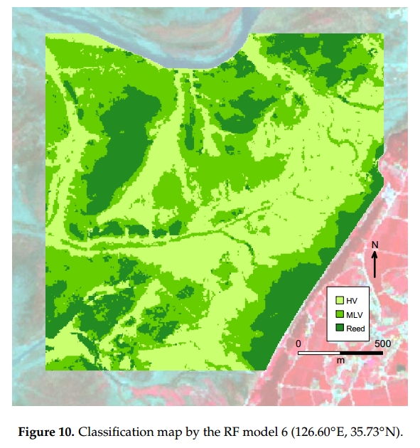
The aim of this study is to adapt and evaluate the effectiveness of a multi-temporal downscaled images technique for classifying the typical vegetation types of a reclaimed area. The areas reclaimed from estuarine tidal flats show high spatial heterogeneity in soil salinity conditions. There are three typical vegetation types for which the distribution is restricted by the soil conditions. A halophyte-dominated vegetation is located in a high saline area, grass vegetation is found in a mid- or low saline area, and reed/small-reed vegetation is situated in a low saline area. Multi-temporal satellite images were used to classify the vegetation types. Landsat images were downscaled to take into account spatial heterogeneity using cokriging. A random forest classifier was used for the classification, with downscaled Landsat and RapidEye images. Classification with RapidEye images alone demonstrated a lower level of accuracy than when combined with multi-temporal downscaled images. The results demonstrate the usefulness of a downscaling technique for mapping. This approach can provide a framework which is able to maintain low costs whilst producing richer images for the monitoring of a large and heterogeneous ecosystem. |
|||
| 출처 | Remote Sensing | ||
| 이전글 | SPI를 활용한 GPM IMERG 자료의 적용성 평가 |
|---|---|
| 다음글 | Timesat 프로그램에 의한 한반도 활엽수의 지역별 MODIS LAI 및 NDVI 패턴 분석 |
연관위성영상
-
 미국:자유의 여신상(2023-11-03)
2023-11-14
-
 리비아:데르나 홍수(2023-09-13)
2023-09-18
-
 스페인:홍수(2023-09-06)
2023-09-14
연관활용사례
-
다목적실용위성 3A 영상정보의...
지리
2024-05-13
-
KOMSPAT-3 광학 영상과...
토양
2024-05-10
-
The Impact of GC...
해양
2024-05-10
연관미디어
-
항우연
천리안위성 2A호, 스마...
2019-07-25
-
항우연
천리안위성 2A호가 최초...
2019-02-07

네팔:지진(2015-05-05)
| 카테고리 | 재난재해 |
|---|---|
| 위성정보 | KOMPSAT-3 |
| 생성일 | 2015-03-24 |
세부정보
| ProductID | K3_20150505073608_15817_06161210 |
|---|---|
| 국가(영문) | Nepal |
| 국가 | 네팔 |
| 지역 | Pokhara |
| 레벨 | 1R |