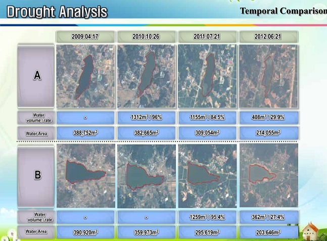
활용사례
| 제목 | Disaster management using satellite imagery at Korea | ||
|---|---|---|---|
| 국/내외 | 국내 | 작성일 | 2017-08-28 |
|
Abstract |
|||
| 출처 | Esri User Conference | ||
| 이전글 | 이탈리아 베수비오 산(Mount Vesuvius) 산불 |
|---|---|
| 다음글 | 스위스 Bondo 산사태 |
연관위성영상
-
 스페인:마드리드 왕궁(2025-05-29)
2025-06-23
-
 이탈리아:Porto di Olbia(2025-05-25)
2025-06-09
-
 미국:Spokane Falls(2025-05-24)
2025-06-09
연관활용사례
-
Applicability of...
환경
2025-07-07
-
Lake detection a...
환경
2025-07-01
-
Flood in Brazil
재해
2025-06-26
최신미디어
-
보도자료
나라스페이스, 경기도와 ...
2025-06-11
-
과기정통부
47m 누리호, 우주의 ...
2025-05-29
-
항우연
한국항공우주연구원 홈페이...
2025-05-16

네팔:지진(2015-05-05)
| 카테고리 | 재난재해 |
|---|---|
| 위성정보 | KOMPSAT-3 |
| 생성일 | 2015-03-24 |
세부정보
| ProductID | K3_20150505073608_15817_06161210 |
|---|---|
| 국가(영문) | Nepal |
| 국가 | 네팔 |
| 지역 | Pokhara |
| 레벨 | 1R |