활용사례
| 제목 | Robust Change Vector Analysis (RCVA) for multi-sensor very high resolution optical satellite data | ||
|---|---|---|---|
| 국/내외 | 국외 | 작성일 | 2017-08-29 |
|
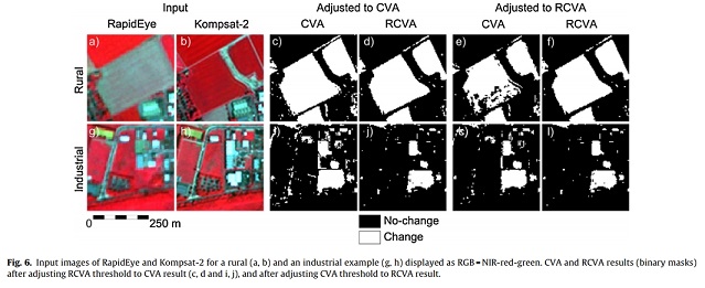
The analysis of rapid land cover/land use changes by means of remote sensing is often based on data acquired under varying and occasionally unfavorable conditions. In addition, such analyses frequently use data acquired by different sensor systems. These acquisitions often differ with respect to sun position and sensor viewing geometry which lead to characteristic effects in each image. These differences may have a negative impact on reliable change detection. Here, we propose an approach called Robust Change Vector Analysis (RCVA), aiming to mitigate these effects. RCVA is an improvement of the widely-used Change Vector Analysis (CVA), developed to account for pixel neighborhood effects. We used a RapidEye and Kompsat-2 cross-sensor change detection test to demonstrate the efficiency of RCVA. Our analysis showed that RCVA results in fewer false negatives as well as false positives when compared to CVA under similar test conditions. We conclude that RCVA is a powerful technique which can be utilized to reduce spurious changes in bi-temporal change detection analyses based on high- or very-high spatial resolution imagery. |
|||
| 출처 | International Journal of Applied Earth Observation and Geoinformation | ||
| 이전글 | 생태 모니터링을 위한 초분광 영상 활용 연구 |
|---|---|
| 다음글 | Multisensor approach to oil palm plantation monitoring using data fusion and GIS |
연관위성영상
-
 미국:자유의 여신상(2023-11-03)
2023-11-14
-
 리비아:데르나 홍수(2023-09-13)
2023-09-18
-
 스페인:홍수(2023-09-06)
2023-09-14
연관활용사례
-
항공영상을 이용한 다목적실용위...
지리
2024-04-24
-
SSResUnet 모델을 이용...
토양
2024-04-19
-
고해상도 위성 데이터 처리를 ...
지리
2024-03-15
최신미디어
-
과기정통부
국내 최초 양산형 초소형...
2024-04-26
-
과기정통부
초소형군집위성 1호 발사...
2024-04-24

네팔:지진(2015-05-05)
| 카테고리 | 재난재해 |
|---|---|
| 위성정보 | KOMPSAT-3 |
| 생성일 | 2015-03-24 |
세부정보
| ProductID | K3_20150505073608_15817_06161210 |
|---|---|
| 국가(영문) | Nepal |
| 국가 | 네팔 |
| 지역 | Pokhara |
| 레벨 | 1R |