활용사례
| 제목 | Comparison of SWAT streamflow and water quality in an agricultural watershed using KOMPSAT-2 and Landsat land use information | ||
|---|---|---|---|
| 국/내외 | 국내 | 작성일 | 2017-10-18 |
|
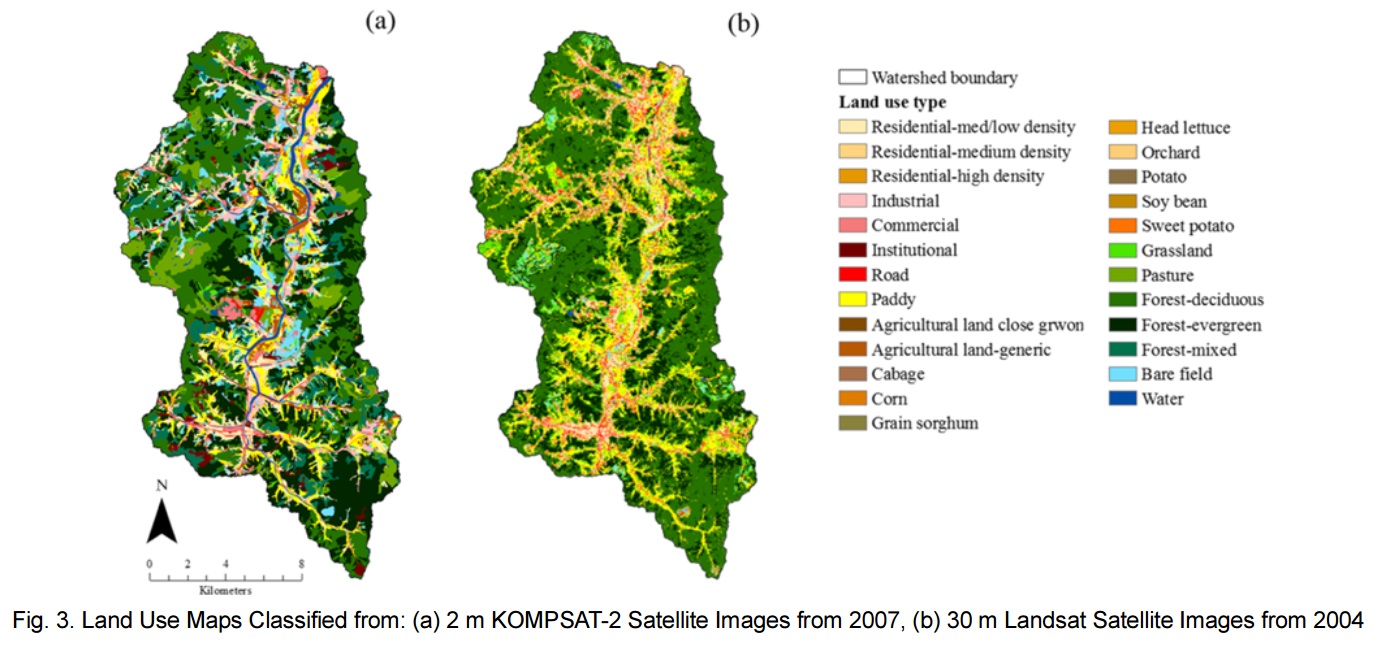
This study investigated streamflow and water quality using the Soil and Water Assessment Tool (SWAT) and by applying two land use datasets from KOrea Multi-Purpose SATellite (KOMPSAT)-2 and Landsat TM (Thematic Mapper) images. For a 262.3 km2 agricultural watershed located in the northwest part of South Korea, the Landsat TM and KOMPSAT-2 could produce 8 and 25 land use classes from spatial resolutions of 30 m and 2 m, respectively. For each land use condition, the SWAT model was calibrated and validated using 8 years (2000-2007) of daily streamflow and monthly sediment, Total Nitrogen (T-N), and Total Phosphorous (T-P) data. The average Nash-Sutcliffe model Efficiencies (NSEs) of streamflow for KOMPSAT-2 and Landsat were 0.80 and 0.71, respectively. The average NSEs of sediment, T-N, and T-P were 0.52, 0.97, and 0.67 for KOMPSAT-2 and 0.30, 0.77, and 0.35 for Landsat, respectively. From the difference in the areal statistics and distribution between the two land uses, the key parameter for streamflow calibration was SCS-CN (Soil Conservation Service-CN). The watershed average SCS-CN value from KOMPSAT-2 was 1.05-fold greater than that from Landsat TM. The larger SCS-CN value increased the surface runoff and subsequently increased the sediment, T-N and T-P transport in the stream. |
|||
| 출처 | KSCE Journal of Civil Engineering | ||
| 이전글 | A comparative study on multi-class SVM & kernel function for land cover classification in a KOMPSAT-2 image |
|---|---|
| 다음글 | 고해상도 다중시기 위성영상을 이용한 밭작물 분류: 마늘/양파 재배지 사례연구 |
연관위성영상
-
 영국:홀리루드 궁전(2022-09-23)
2022-09-28
-
 중국:상하이 디즈니랜드(2022-07-28)
2023-01-05
-
 시리아:시리아의 요새(2022/5/10 )
2022-07-06
연관활용사례
-
SSResUnet 모델을 이용...
토양
2024-04-19
-
KOMPSAT-3와 KOMPS...
토양
2024-04-16
-
Wildfire in Chile
재해
2024-04-04
최신미디어
-
과기정통부
국내 최초 양산형 초소형...
2024-04-26
-
과기정통부
초소형군집위성 1호 발사...
2024-04-24

네팔:지진(2015-05-05)
| 카테고리 | 재난재해 |
|---|---|
| 위성정보 | KOMPSAT-3 |
| 생성일 | 2015-03-24 |
세부정보
| ProductID | K3_20150505073608_15817_06161210 |
|---|---|
| 국가(영문) | Nepal |
| 국가 | 네팔 |
| 지역 | Pokhara |
| 레벨 | 1R |