활용사례

활용 사례
제목 Analysis of height models based on KOMPSAT-3 images
국/내외 국외 작성일 2018-04-05

Analysis of height models based on KOMPSAT-3 images 첨부 이미지

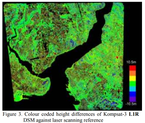
Height models are basic information required for disaster Management. Not in any case satisfying and actual height models are available, but they can be generated by satellite stereo pairs being more precise as InSAR.
The Korean Kompsat-3 has a ground sampling distance of 0.71m. A stereo combination covering the main part of Istanbul has been used for the generation of height models. Kompsat-3 images are available as L1R images, corresponding close to the original image geometry, and as L1G, being projected to the SRTM 3 arcsec height model. For use of Semi Global Matching quasi epipolar images are required. They can be produced by just rotating the L1G-images to the stereo base, while with L1R-images requires at first a projection to a constant height level. The projection of L1G to the SRTM height models leads to height differences against the SRTM heights. The orientation of the L1R images with 71 ground control points (GCP) was possible in X and Y with 0.6 GSD and in Z with 1.1 GSD, while with L1G images only 1.2 GSD respectively 2.9 GSD have been reached. A standard deviation of 0.6 GSD for X and Y and 1.1 GSD for Z is satisfying and a usual accuracy for satellite images. A comparison of the generated height model based on the L1G-images with airborne LiDAR data (ALS) showed clear local systematic height errors of the height model based on L1G-images which could not be seen with L1R-images.
The area based least squares matching leads to good results in open areas while in build up areas no accurate building determination is possible. Here SGM has a clear advantage with accurate roof structures corresponding to the 0.71 m GSD. For the relative accuracy, that means the building height and the roof structure, it does not matter if L1G or L1R images are used.

출처 ISPRS
이전/이후 글
이전글 상대 방사 정규화를 이용한 다시기 적외 위성영상의 변화탐지 비교
다음글 KOMPSAT 5호 InSAR영상을 이용한 DEM제작 정확도 평가

네팔:지진(2015-05-05)

영상 정보
카테고리 재난재해
위성정보 KOMPSAT-3
생성일 2015-03-24

세부정보

영상 세부 정보
ProductID K3_20150505073608_15817_06161210
국가(영문) Nepal
국가 네팔
지역 Pokhara
레벨 1R