

활용사례
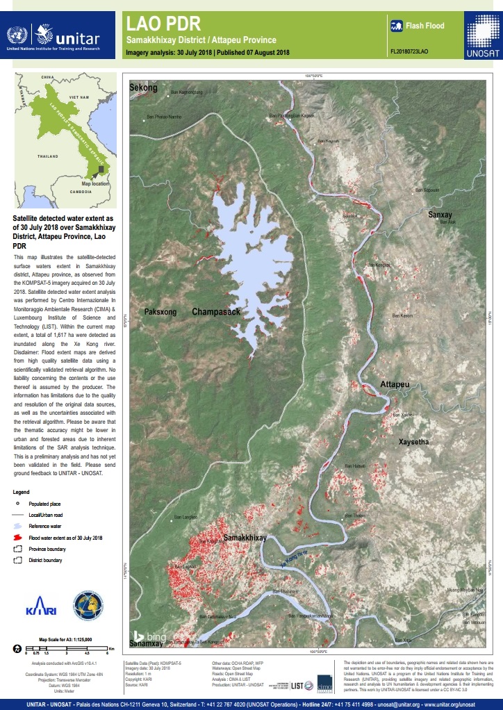
| 제목 | Satellite detected water extent as of 30 July 2018 over Samakkhixay District, Attapeu Province, Lao PDR | ||
|---|---|---|---|
| 국/내외 | 국외 | 작성일 | 2018-08-08 |
|
This map illustrates the satellite-detected surface waters extent in Samakkhixay district, Attapeu province, as observed from the KOMPSAT-5 imagery acquired on 30 July 2018. Satellite detected water extent analysis was performed by Centro Internazionale In Monitoraggio Ambientale Research (CIMA) & Luxembourg Institute of Science and Technology (LIST). Within the current map extent, a total of 1,617 ha were detected as inundated along the Xe Kong river. |
|||
| 출처 | UNOSAT | ||
| 이전글 | 일본: 2018년 7월 폭우 및 산사태로 인한 피해지역 지도화 |
|---|---|
| 다음글 | International Charter: Flood in Venezuela |
연관위성영상
-
 미국:자유의 여신상(2023-11-03)
2023-11-14
-
 리비아:데르나 홍수(2023-09-13)
2023-09-18
-
 스페인:홍수(2023-09-06)
2023-09-14
연관활용사례
-
KOMPSAT-3/3A 영상으...
토양
2024-04-19
-
SSResUnet 모델을 이용...
토양
2024-04-19
-
KOMPSAT-3와 KOMPS...
토양
2024-04-16
연관미디어
-
과기정통부
우리나라 첫 위성 우리별...
2022-08-11
-
과기정통부
2018년 국가 우주개발...
2018-03-29

네팔:지진(2015-05-05)
| 카테고리 | 재난재해 |
|---|---|
| 위성정보 | KOMPSAT-3 |
| 생성일 | 2015-03-24 |
세부정보
| ProductID | K3_20150505073608_15817_06161210 |
|---|---|
| 국가(영문) | Nepal |
| 국가 | 네팔 |
| 지역 | Pokhara |
| 레벨 | 1R |