활용사례
| 제목 | SVM 교차검증을 활용한 토지피복 ROI 선정 | ||
|---|---|---|---|
| 국/내외 | 국내 | 작성일 | 2020-09-28 |
|
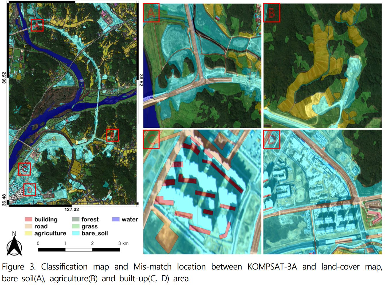
This study examines machine learning cross-validation to utilized create ROI for classification of land cover. The study area located in Sejong and one KOMPSAT-3A image was used in this analysis: procedure on October 28, 2019. We used four bands(Red, Green, Blue, Near infra-red) for learning cross validation process. In this study, we used K-fold method in cross validation and used SVM kernel type with cross validation result. In addition, we used 4 kernels of SVM(Linear, Polynomial, RBF, Sigmoid) for supervised classification land cover map using extracted ROI. During the cross validation process, 1,813 data extracted from 3,500 data, and the most of the building, road and grass class data were removed about 60% during cross validation process. Based on this, the supervised SVM linear technique showed the highest classification accuracy of 91.77% compared to other kernel methods. The grass’ producer accuracy showed 79.43% and identified a large mis-classification in forests. Depending on the results of the study, extraction ROI using cross validation may be effective in forest, water and agriculture areas, but it is deemed necessary to improve the distinction of built-up, grass and bare-soil area. |
|||
| 출처 | 한국국토정보공사 「지적과 국토정보」 | ||
| 이전글 | KOMPSAT-3A 위성영상과 토지피복도를 활용한 산림식생의 임상 분류법 개발 |
|---|---|
| 다음글 | 심층신경망 모델을 이용한 고해상도 KOMPSAT-3 위성영상 기반 토지피복분류 |
최신위성영상
-
 스페인:마드리드 왕궁(2025-05-29)
2025-06-23
-
 이탈리아:Porto di Olbia(2025-05-25)
2025-06-09
-
 미국:Spokane Falls(2025-05-24)
2025-06-09
연관활용사례
-
긴밀도 변화 탐지 기법을 사용...
재해
2025-01-31
-
딥러닝 기반 구름 및 구름 그...
지리
2024-11-11
-
HRNet과 Transform...
지리
2024-10-02
연관미디어
-
항우연
누리호 3차 발사 비행정...
2023-06-26
-
항우연
한국항공우주연구원항우연 ...
2023-01-04

네팔:지진(2015-05-05)
| 카테고리 | 재난재해 |
|---|---|
| 위성정보 | KOMPSAT-3 |
| 생성일 | 2015-03-24 |
세부정보
| ProductID | K3_20150505073608_15817_06161210 |
|---|---|
| 국가(영문) | Nepal |
| 국가 | 네팔 |
| 지역 | Pokhara |
| 레벨 | 1R |