활용사례
| 제목 | Application of High-spatial-resolution Satellite Images to Monitoring Coral Reef Habitat Changes at Weno Island Chuuk, Micronesia | ||
|---|---|---|---|
| 국/내외 | 국내 | 작성일 | 2021-09-03 |
|
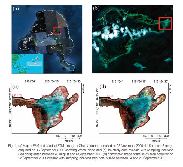
We present quantitative estimations of changes in the areal extent of coral reef habitats at Weno Island, Micronesia, using high-spatial-resolution remote sensing images and field observations. Coral reef habitat maps were generated from Kompsat-2 satellite images for September 2008 and September 2010, yielding classifications with 78.6% and 72.4% accuracy, respectively, which is a relatively high level of agreement. The difference between the number of pixels occupied by each seabed type was calculated, revealing that the areal extent of living corals decreased by 8.2 percentage points between 2008 and 2010. This result is consistent with a comparison of the seabed types determined by field observations. This study can be used as a basis for remediation planning to diminish the impact of changes in coral reefs. |
|||
| 출처 | 대한원격탐사학회지 | ||
| 이전글 | 이 황사가 몽골에서 왔다고? 위성사진으로 확인 들어갑니다. |
|---|---|
| 다음글 | 천리안위성 2A호 고속 관측 영상의 시·공간 해상도가 중규모 대기운동벡터 산출에 미치는 영향 분석 |
연관위성영상
-
 스페인:마드리드 왕궁(2025-05-29)
2025-06-23
-
 이탈리아:Porto di Olbia(2025-05-25)
2025-06-09
-
 미국:Spokane Falls(2025-05-24)
2025-06-09
연관활용사례
-
Lake detection a...
환경
2025-07-01
-
Flood in Brazil
재해
2025-06-26
-
KOMPSAT-5 영상과 RP...
지리
2025-06-23
최신미디어
-
과기정통부
47m 누리호, 우주의 ...
2025-05-29
-
항우연
한국항공우주연구원 홈페이...
2025-05-16

네팔:지진(2015-05-05)
| 카테고리 | 재난재해 |
|---|---|
| 위성정보 | KOMPSAT-3 |
| 생성일 | 2015-03-24 |
세부정보
| ProductID | K3_20150505073608_15817_06161210 |
|---|---|
| 국가(영문) | Nepal |
| 국가 | 네팔 |
| 지역 | Pokhara |
| 레벨 | 1R |