활용사례
| 제목 | Derivation of Surface Temperature from KOMPSAT-3A Mid-wave Infrared Data Using a Radiative Transfer Model | ||
|---|---|---|---|
| 국/내외 | 국내 | 작성일 | 2022-09-07 |
|
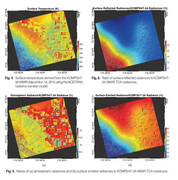
An attempt to derive the surface temperature from the Korea Multi-purpose Satellite (KOMPSAT)- 3A mid-wave infrared (MWIR) data acquired over the southern California on Nov. 14, 2015 has been made using the MODerate resolution atmospheric TRANsmission (MODTRAN) radiative transfer model. Since after the successful launch on March 25, 2015, the KOMPSAT-3A spacecraft and its two payload instruments — the high-resolution multispectral opticalsensor and the scanner infrared imaging system (SIIS) — continue to operate properly. SIIS uses the MWIR spectral band of 3.3–5.2 μm for data acquisition. As input data for the realistic simulation of the KOMPSAT-3A SIIS imaging conditions in the MODTRAN model, we used the National Centersfor Environmental Prediction (NCEP) atmospheric profiles, the KOMPSAT-3Asensor response function, the solar and line-of-sight geometry, and the University of Wisconsin emissivity database. The land cover type of the study area includes water,sand, and agricultural (vegetated) land located in the southern California. Results of surface temperature showed the reasonable geographical pattern over water, sand, and agricultural land. It is however worthwhile to note that the surface temperature pattern does not resemble the top-of-atmosphere (TOA) radiance counterpart. Thisis because MWIRTOAradiances consist of both shortwave (0.2–5 μm) and longwave (5–50 μm) components and the surface temperature dependssolely upon the surface emitted radiance of longwave components. We found in our case that the shortwave surface reflection primarily causes the difference of geographical pattern between surface temperature and TOA radiance. Validation of the surface temperature for this study is practically difficult to perform due to the lack of ground truth data. We therefore made simple comparisons with two datasets over Salton Sea: National Aeronautics and Space Administration (NASA) Jet Propulsion Laboratory (JPL) field data and Salton Sea data. The current estimate differs with these datasets by 2.2 K and 1.4 K, respectively, though it seems not possible to quantify factors causing such differences. |
|||
| 출처 | 대한원격탐사학회지 | ||
| 이전글 | 농경지 관측을 위한 KOMPSAT 대기보정 적용 및 평가 |
|---|---|
| 다음글 | KOMPSAT-3와 Sentinel-1 SAR 영상을 적용한 토양 수분도와 NDWI 결과 비교 분석 |
연관위성영상
-
 미국:Spokane Falls(2025-05-24)
2025-06-09
-
 호주:Cactus Beach(2025-05-21)
2025-06-23
-
 독일:라이프치히 할레 공항(2025-05-06)
2025-06-09
연관활용사례
-
Applicability of...
환경
2025-07-07
-
Lake detection a...
환경
2025-07-01
-
Flood in Brazil
재해
2025-06-26
연관미디어
-
항우연
천리안위성 2A호, 스마...
2019-07-25
-
항우연
천리안위성 2A호가 최초...
2019-02-07

네팔:지진(2015-05-05)
| 카테고리 | 재난재해 |
|---|---|
| 위성정보 | KOMPSAT-3 |
| 생성일 | 2015-03-24 |
세부정보
| ProductID | K3_20150505073608_15817_06161210 |
|---|---|
| 국가(영문) | Nepal |
| 국가 | 네팔 |
| 지역 | Pokhara |
| 레벨 | 1R |