활용사례
| 제목 | Slope-Aspect 알고리즘을 활용한 강릉시 산불 피해지역 실표면적 산출 방법 | ||
|---|---|---|---|
| 국/내외 | 국내 | 작성일 | 2022-10-26 |
|
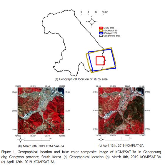
This study aims to find the exact area of the forest fire in Okgye-myeon, Gangneung, April 4, 2019. Since there is a gradient in our country's forests, we should find a surface area that takes into account The 5th numerical clinical map provided by the DEM and the Korea Forest Service provided by the National Geographic Information Service was used. In DEM, the center point of each pixel was created and all points were connected. The length of the connecting line is determined by the spatial resolution of the pixel and the cosine value, and the surface area is obtained along with the height value, which is called the Slope-Aspect algorithm. The surface area and floor area of the forest were shown according to the tree species and types of forest, and their quantitative numerical differences proved the validity of this study. |
|||
| 출처 | 한국국토정보공사 | ||
| 이전글 | International Charter:Typhoon Noru in Thailand |
|---|---|
| 다음글 | Oil spill in Mauritius |
연관위성영상
-
 미국:LA 산불(2025-01-09)
2025-01-31
-
 미국:하일랜드 산불(2024-09-14)
2024-09-26
-
 칠레:칠레 발파라조 산불(2024-02-06)
2024-05-21
연관활용사례
-
긴밀도 변화 탐지 기법을 사용...
재해
2025-01-31
-
딥러닝 기반 구름 및 구름 그...
지리
2024-11-11
-
HRNet과 Transform...
지리
2024-10-02
연관미디어
-
항우연
한국항공우주연구원항우연 ...
2023-01-04
-
항우연
뉴스페이스 시대, 위성정...
2022-12-02

네팔:지진(2015-05-05)
| 카테고리 | 재난재해 |
|---|---|
| 위성정보 | KOMPSAT-3 |
| 생성일 | 2015-03-24 |
세부정보
| ProductID | K3_20150505073608_15817_06161210 |
|---|---|
| 국가(영문) | Nepal |
| 국가 | 네팔 |
| 지역 | Pokhara |
| 레벨 | 1R |