활용사례
| 제목 | Atmospheric Correction of True-Color RGB Imagery with Limb Area-Blending Based on 6S and Satellite Image Enhancement Techniques Using Geo-Kompsat-2A Advanced Meteorological Imager Data | ||
|---|---|---|---|
| 국/내외 | 국내 | 작성일 | 2022-10-26 |
|
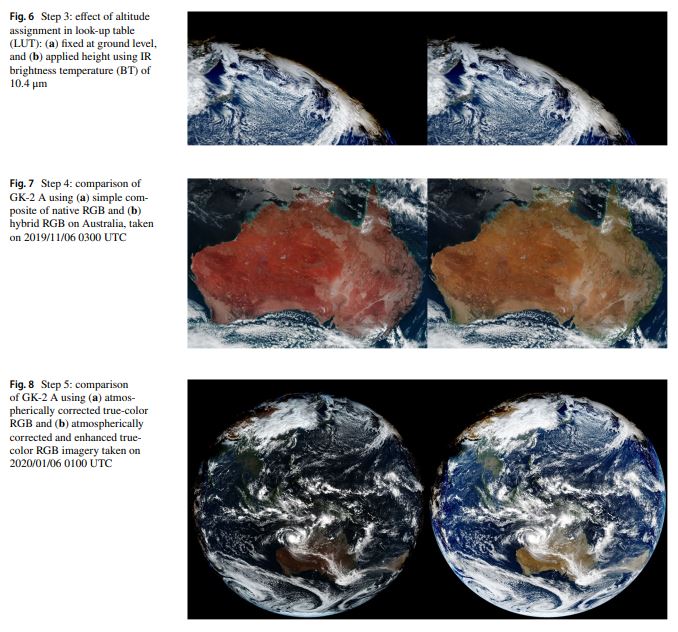
This study aims for producing high-quality true-color red-green-blue (RGB) imagery that is useful for interpreting various environmental phenomena, particularly for GK2A. Here we deal with an issue that general atmospheric correction methods for RGB imagery might be breakdown at high solar/viewing zenith angle of GK2A due to erroneous atmospheric path lengths. Additionally, there is another issue about the green band of GK2A of which centroid wavelength (510 nm) is diferent from that of natural green band (555 nm), resulting in the unrealistic RGB imagery. To overcome those weakness of the RGB imagery for GK2A, we apply the second simulation of the satellite signal in the solar spectrum radiative transfer model lookup table with improved information considering altitude of the refective surface to reduce the exaggerated atmospheric correction, and a blending technique that mixed the true-color imagery before and after atmospheric correction which produced a naturally expressed true-color image. Consequently, the root mean square error decreased by 0.1–0.5 in accordance with the solar and view zenith angles. The green band signal was modifed by combining it with a veggie band to form hybrid green which adjust centroid wavelength of approximately 550 nm. The original composite of true-color RGB imagery is dark; therefore, to brighten the imagery, histogram equalization is conducted to fatten the color distribution. High-temporalresolution true-color imagery from the GK2A AMI have signifcant potential to provide scientists and forecasters as a tools to visualize the changing Earth and also expected to intuitively understand the atmospheric phenomenon to the general public. |
|||
| 출처 | 한국기상학회 | ||
| 이전글 | 심층신경망을 이용한 KOMPSAT-3/3A/5 영상으로부터 자연림과 인공림의 분류 |
|---|---|
| 다음글 | Incremental Learning with Neural Network Algorithm for the Monitoring Pre-Convective Environments Using Geostationary Imager |
연관위성영상
-
 보츠와나:내셔널 스타디움(2024-06-11)
2024-06-21
-
 중국:Kunlunhu Lake(2024-06-11)
2024-06-21
-
 미국:제럴드 R.포드 국제공항(2024-06-10)
2024-06-21
연관활용사례
-
Flood in South K...
재해
2024-07-23
-
KOMPSAT-3/3A 광학 ...
환경
2024-07-22
-
천리안위성 2A호 지구정지궤도...
지리
2024-07-22
최신미디어
-
항우연
누리호 4차 발사를 위한...
2024-07-09
-
항우연
한국항공우주연구원-한국인...
2024-07-09

네팔:지진(2015-05-05)
| 카테고리 | 재난재해 |
|---|---|
| 위성정보 | KOMPSAT-3 |
| 생성일 | 2015-03-24 |
세부정보
| ProductID | K3_20150505073608_15817_06161210 |
|---|---|
| 국가(영문) | Nepal |
| 국가 | 네팔 |
| 지역 | Pokhara |
| 레벨 | 1R |