활용사례
| 제목 | 중복 딥러닝 모델을 이용한 KOMPSAT 광학영상에서의 농촌시설 분할에 대한 연구 | ||
|---|---|---|---|
| 국/내외 | 국내 | 작성일 | 2025-02-13 |
|
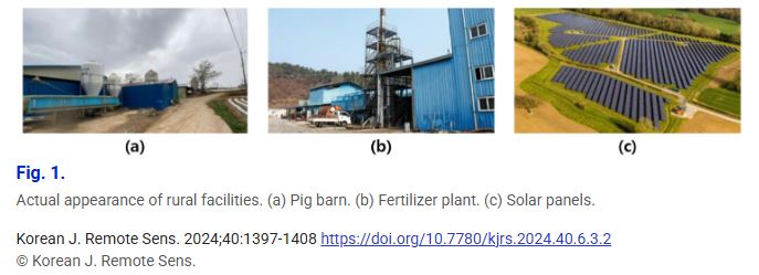
Rural facilities such as factories and barns near residential areas cause pollution and civil complaints. They are managed through legal registration, but there are still conflicts and inconsistencies. In Korea, the Rural Spatial Restructuring Act will come into effect in March this year. It will promote long-term rural area construction plans and support new public businesses. In this situation, it is essential to have a means to accurately and efficiently identify the status and changes in rural facilities. In this study, we constructed a dataset containing the Korea Multi-purpose Satellite (KOMPSAT) optical images and associated rural facility masks for four cities in South Korea in 2019 and 2020. A deep learning-based segmentation method was then applied to the dataset. Satellite images only show roofs, making it inherently difficult to completely distinguish between building types. Non-target buildings often look almost identical to the target. The higher the complexity of the deep neural network architecture, the more likely these inconsistencies are to cause overfitting problems. For better universal performance, we constructed redundant models from different combinations of data. Redundant models produce different inference results for the same validation sample. Averaging this gives more reliable results. Finally, we also performed a performance comparison between the original model and the new model optimized within the trust region guaranteed by the redundant models. |
|||
| 출처 | 원격탐사학회 | ||
| 이전글 | 딥러닝 기법을 사용한 고해상도 위성 영상 기반의 야적퇴비 탐지 방법론 제시 |
|---|---|
| 다음글 | Development of Agricultural Parcel Detection Model based on YOLO-Seg Using CAS500-1 Satellites Images |
연관위성영상
-
 스페인:마드리드 왕궁(2025-05-29)
2025-06-23
-
 이탈리아:Porto di Olbia(2025-05-25)
2025-06-09
-
 미국:Spokane Falls(2025-05-24)
2025-06-09
연관활용사례
-
Lake detection a...
환경
2025-07-01
-
KOMPSAT-5 영상과 RP...
지리
2025-06-23
-
Applicability of...
환경
2025-06-16
연관미디어
-
항우연
한국항공우주연구원 홈페이...
2025-05-16
-
항우연
항우연 제13대 이상철 ...
2025-01-22

네팔:지진(2015-05-05)
| 카테고리 | 재난재해 |
|---|---|
| 위성정보 | KOMPSAT-3 |
| 생성일 | 2015-03-24 |
세부정보
| ProductID | K3_20150505073608_15817_06161210 |
|---|---|
| 국가(영문) | Nepal |
| 국가 | 네팔 |
| 지역 | Pokhara |
| 레벨 | 1R |