활용사례
| 제목 | Generation of Simulated Satellite Images for the CAS500-4 by Inverse Orthorectification | ||
|---|---|---|---|
| 국/내외 | 국내 | 작성일 | 2025-02-26 |
|
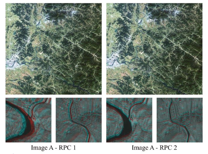
The Compact Advanced Satellite 500-4 (CAS500-4) is scheduled for launch in 2025 and is expected to play a significant role in monitoring agricultural and forest resources across the Korean Peninsula. However, the absence of actual CAS500-4 data prior to launch presents challenges for pre-launch research and verification, which constrains the ability to reflect the distinctive attributes of the satellite accurately. To address this issue, this study proposes a method for generating CAS500-4 Level-1 Radiometric (L1R) simulated images by inverse orthorectification based on the rational function model (RFM). Sentinel-2 orthoimages were used as the base image, and rational polynomial coefficients (RPCs) collected from Korea Multi-Purpose Satellite-3A (KOMPSAT-3A) were adjusted and utilized. The objective was to meet the ground sample distance (GSD) requirement of 5 m, consistent with CAS500-4 specifications, and to simulate different viewing angles from the base orthoimage using adjusted RPCs. The results demonstrated that the proposed method established a relationship with the base orthoimage and generated L1R simulated images. These simulated images provide a reliable basis for validating operational processes and preparing for various applications, ensuring effective utilization of CAS500-4 during its early operations. |
|||
| 출처 | 한국원격탐사학회 | ||
| 이전글 | 긴밀도 변화 탐지 기법을 사용한 화산 분화에 의한 지표 변화 분석(2024년 5월 아이슬란드 화산 분화를 중심으로) |
|---|---|
| 다음글 | Flooding in Argentina |
연관위성영상
-
 스페인:마드리드 왕궁(2025-05-29)
2025-06-23
-
 이탈리아:Porto di Olbia(2025-05-25)
2025-06-09
-
 미국:Spokane Falls(2025-05-24)
2025-06-09
연관활용사례
-
Lake detection a...
환경
2025-07-01
-
Flood in Brazil
재해
2025-06-26
-
KOMPSAT-5 영상과 RP...
지리
2025-06-23
최신미디어
-
과기정통부
47m 누리호, 우주의 ...
2025-05-29
-
항우연
한국항공우주연구원 홈페이...
2025-05-16

네팔:지진(2015-05-05)
| 카테고리 | 재난재해 |
|---|---|
| 위성정보 | KOMPSAT-3 |
| 생성일 | 2015-03-24 |
세부정보
| ProductID | K3_20150505073608_15817_06161210 |
|---|---|
| 국가(영문) | Nepal |
| 국가 | 네팔 |
| 지역 | Pokhara |
| 레벨 | 1R |