활용사례
| 제목 | Satellite Imagery Analysis for Environmental Monitoring: Turkmenbashi, Turkmenistan | ||
|---|---|---|---|
| 국/내외 | 국외 | 작성일 | 2015-03-23 |
|
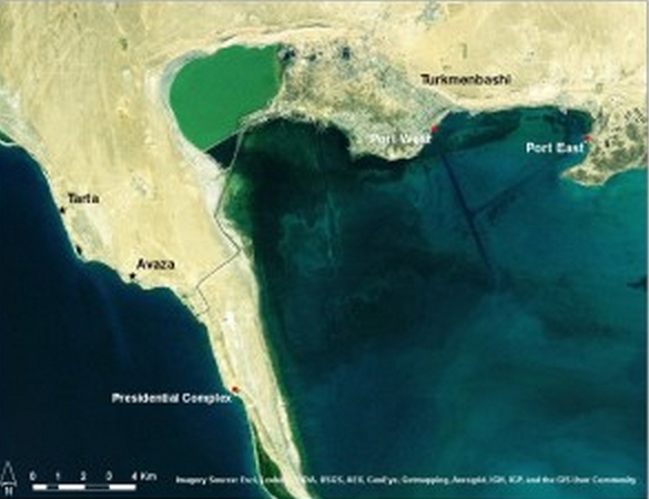
In June 2012, AAAS initiated a project focused on Turkmenbashi, Turkmenistan (Figure 1). The period of review was from 2000 to 2012. This project was conducted in collaboration with Crude Accountability and the Turkmen Initiative for Human Rights. The goal of the project was to use satellite imagery to investigate reports of environmental pollution in the waters adjacent to the port of Turkmenbashi, Turkmenistan (Figure 1). |
|||
| 출처 | AAAS | ||
| 이전글 | GIS와 위성영상을 이용한 토지피복변화에 따른토양유실량 산정 |
|---|---|
| 다음글 | Monitoring Environmental Destruction From the Sky |
연관위성영상
-
 미국:자유의 여신상(2023-11-03)
2023-11-14
-
 리비아:데르나 홍수(2023-09-13)
2023-09-18
-
 스페인:홍수(2023-09-06)
2023-09-14
연관활용사례
-
다목적실용위성 3A 영상정보의...
지리
2024-05-13
-
KOMSPAT-3 광학 영상과...
토양
2024-05-10
-
The Impact of GC...
해양
2024-05-10
최신미디어
-
과기정통부
국내 최초 양산형 초소형...
2024-04-26
-
과기정통부
초소형군집위성 1호 발사...
2024-04-24

네팔:지진(2015-05-05)
| 카테고리 | 재난재해 |
|---|---|
| 위성정보 | KOMPSAT-3 |
| 생성일 | 2015-03-24 |
세부정보
| ProductID | K3_20150505073608_15817_06161210 |
|---|---|
| 국가(영문) | Nepal |
| 국가 | 네팔 |
| 지역 | Pokhara |
| 레벨 | 1R |