활용사례
| 제목 | USE OF SATELLITE IMAGERY FOR DEM EXTRACTION, LANSCAPE MODELING AND GIS APPLICATIONS | ||
|---|---|---|---|
| 국/내외 | 국외 | 작성일 | 2016-03-24 |
|
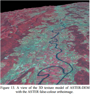
This paper describes a workflow for the DEM extraction from unrectified satellite stereo scenes, its visualization and integration in GIS environment. The results obtained using a stereo scene acquired by EOS-AM1/ASTER over Switzerland are presented and commented. The images are oriented with a rigorous photogrammetric model for CCD linear array sensors developed at IGP (ETH Zurich). The model estimates the sensor internal and external orientation with least squares adjustment, using a suitable number of ground control points. For the DEM generation, the points are automatically extracted in the images at sub-pixel accuracy with a least squares matching algorithm and their 3D coordinates are then calculated with forward intersection using the external and internal parameters estimated during the image orientation. The accuracy of the DEM was evaluated in three test areas using the DHM25 by Swisstopo as reference. The RMSE of the 3D distance between the recovered and reference terrain models is in the order of 1 pixel. After the surface generation, the terrain model is used for further investigations within a commercial GIS package. This includes not only the DEM analysis and comparison with already available geodata, but also the integration of cartographic information (i.e. existing vector features). The achieved results demonstrate the great potential of ASTER satellite imagery for geomatic applications at medium scales. Finally the DEM is imported in commercial software for a photo-realistic visualization. |
|||
| 출처 | isprs.org | ||
| 이전글 | 지도로 보는 서울시 변천사 |
|---|---|
| 다음글 | GIS-DRIVEN CLASSIFICATION OF SATELLITE IMAGERY |
연관위성영상
-
 미국:자유의 여신상(2023-11-03)
2023-11-14
-
 리비아:데르나 홍수(2023-09-13)
2023-09-18
-
 스페인:홍수(2023-09-06)
2023-09-14
연관활용사례
-
SSResUnet 모델을 이용...
토양
2024-04-19
-
Wildfire in Chile
재해
2024-04-04
-
아리랑 위성 5호 SAR 스테...
지리
2024-03-15
최신미디어
-
과기정통부
국내 최초 양산형 초소형...
2024-04-26
-
과기정통부
초소형군집위성 1호 발사...
2024-04-24

네팔:지진(2015-05-05)
| 카테고리 | 재난재해 |
|---|---|
| 위성정보 | KOMPSAT-3 |
| 생성일 | 2015-03-24 |
세부정보
| ProductID | K3_20150505073608_15817_06161210 |
|---|---|
| 국가(영문) | Nepal |
| 국가 | 네팔 |
| 지역 | Pokhara |
| 레벨 | 1R |