활용사례
| 제목 | Sustainable Surface Deformation Related with 2006 Augustine Volcano Eruption in Alaska Measured Using GPS and InSAR | ||
|---|---|---|---|
| 국/내외 | 국외 | 작성일 | 2016-11-30 |
|
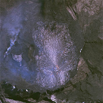
Augustine volcano, located along the Aleutian Arc, is one of the most active volcanoes in Alaska and nearby islands, with seven eruptions occurring between 1812 and 2006. This study monitored the surface displacement before and after the most recent 2006 eruption. For analysis, we conducted a time-series analysis on data observed at the permanent GPS(Global Positioning System) observation stations in Augustine Island between 2005 and 2011. According to the surface displacement analysis results based on GPS data, the movement of the surface inflation at the average speed of 2.3 cm/year three months prior to the eruption has been clearly observed, with the post-eruption surface deflation at the speed of 1.6 cm/year. To compare surface displacements measurement by GPS observation, ENVISAT(Environmental satellite) radar satellite data were collected between 2003 and 2010 and processed the SBAS(Small Baseline Subset) method, one of the time-series analysis techniques using multiple InSAR(Interferometric Synthetic Aperture Radar) data sets. This result represents 0.97 correlation value between GPS and InSAR time-series surface displacements. This research has been completed precise surface deformation using GPS and time-series InSAR methods for a detection of precursor symptom on Augustine volcano. |
|||
| 출처 | 한국측량학회지(ScienceON 제공) | ||

| 이전글 | 위성정보를 활용한 시·공간적으로 분포되어 있는 토양수분산정 및 활용방안 |
|---|---|
| 다음글 | Cochlodinium polykrikoides 적조 발생시의 한국 남해안 고흥 연안의 해양환경 특징 |
연관위성영상
-
 하와이:할레마우마우 분화구(2023-01-07)
2023-01-13
-
 코스타리카:포아스 화산(2022/2/20 )
2022-06-22
-
 인도네시아:탐보라 산(2020-06-28)
2020-07-02
연관활용사례
-
SSResUnet 모델을 이용...
토양
2024-04-19
-
Wildfire in Chile
재해
2024-04-04
-
심층신경망과 천리안위성 2A호...
환경
2023-10-30
연관미디어
-
항우연
한국·유럽 초정밀 GPS...
2016-10-27

네팔:지진(2015-05-05)
| 카테고리 | 재난재해 |
|---|---|
| 위성정보 | KOMPSAT-3 |
| 생성일 | 2015-03-24 |
세부정보
| ProductID | K3_20150505073608_15817_06161210 |
|---|---|
| 국가(영문) | Nepal |
| 국가 | 네팔 |
| 지역 | Pokhara |
| 레벨 | 1R |