활용사례
| 제목 | How Satellite Data Changed Chimpanzee Conservation Efforts | ||
|---|---|---|---|
| 국/내외 | 국외 | 작성일 | 2017-02-24 |
|
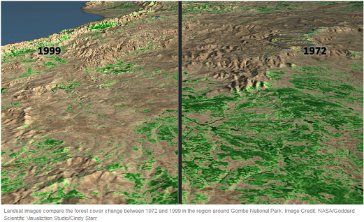
Working in partnership with the villagers, the monitoring data they collect combined with a variety of remote sensing imagery, including the Landsat satellite data, has helped Pintea and colleagues in the scientific community better track and understand the relationship between chimpanzee habitat needs and the status of forest habitats. Among the questions they ask are, as the land changes, how do forests, watersheds and chimpanzees respond, and where are the most opportunities to restore and protect critical watersheds and chimpanzee habitats? They then take that information back to the villages surrounding Gombe so the villagers can make science-based conservation and land use decisions, such as where to restrict logging activities. |
|||
| 출처 | landsat.gsfc.nasa.gov | ||
| 이전글 | 자동화된 훈련 자료를 활용한 Landsat-8 OLI 위성영상의 반복적 분광혼합모델 기반 무감독 분류 |
|---|---|
| 다음글 | NASA Data Show California's San Joaquin Valley Still Sinking |
연관위성영상
-
 미국:자유의 여신상(2023-11-03)
2023-11-14
-
 리비아:데르나 홍수(2023-09-13)
2023-09-18
-
 스페인:홍수(2023-09-06)
2023-09-14
연관활용사례
-
SSResUnet 모델을 이용...
토양
2024-04-19
-
고해상도 위성 데이터 처리를 ...
지리
2024-03-15
-
KOMPSAT-3/3A 영상 ...
해양
2023-12-04
최신미디어
-
과기정통부
국내 최초 양산형 초소형...
2024-04-26
-
과기정통부
초소형군집위성 1호 발사...
2024-04-24

네팔:지진(2015-05-05)
| 카테고리 | 재난재해 |
|---|---|
| 위성정보 | KOMPSAT-3 |
| 생성일 | 2015-03-24 |
세부정보
| ProductID | K3_20150505073608_15817_06161210 |
|---|---|
| 국가(영문) | Nepal |
| 국가 | 네팔 |
| 지역 | Pokhara |
| 레벨 | 1R |