활용사례
| 제목 | NASA Data Show California's San Joaquin Valley Still Sinking | ||
|---|---|---|---|
| 국/내외 | 국외 | 작성일 | 2017-03-03 |
|
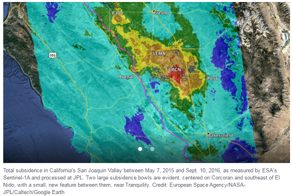
To determine the extent to which additional groundwater pumping associated with California's current historic drought, which began in 2012, has affected land subsidence in the Central Valley, California's Department of Water Resources (DWR) commissioned NASA's Jet Propulsion Laboratory, Pasadena, California, to use its expertise in collecting and analyzing airborne and satellite radar data. An initial report of the JPL findings (Aug. 2015) analyzed radar data from several different sensors between 2006 and early 2015. Due to the continuing drought, DWR subsequently commissioned JPL to collect and analyze new radar images from 2015 and 2016 to update DWR on the land subsidence. |
|||
| 출처 | www.jpl.nasa.gov | ||
| 이전글 | How Satellite Data Changed Chimpanzee Conservation Efforts |
|---|---|
| 다음글 | 북한 환경정보 구축 및 활용 방안 연구 (Ⅰ) : 토지피복지도 구축을 중심으로 |
연관위성영상
-
 스페인:산 라파엘(2023-04-14)
2023-10-30
-
 미국:골든게이트 교(2022-06-28)
2022-07-15
-
 볼리비아:Laguna Colorado(2021-03-16)
2021-04-06
연관활용사례
-
KOMSPAT-3 광학 영상과...
토양
2024-05-10
-
The Impact of GC...
해양
2024-05-10
-
KOMPSAT-3와 KOMPS...
토양
2024-04-16
연관미디어
-
항우연
NASA와 함께 달 표면...
2021-08-31

네팔:지진(2015-05-05)
| 카테고리 | 재난재해 |
|---|---|
| 위성정보 | KOMPSAT-3 |
| 생성일 | 2015-03-24 |
세부정보
| ProductID | K3_20150505073608_15817_06161210 |
|---|---|
| 국가(영문) | Nepal |
| 국가 | 네팔 |
| 지역 | Pokhara |
| 레벨 | 1R |