활용사례
| 제목 | Monitoring Mount Sinabung in Indonesia Using Multi-Temporal InSAR | ||
|---|---|---|---|
| 국/내외 | 국외 | 작성일 | 2017-07-19 |
|
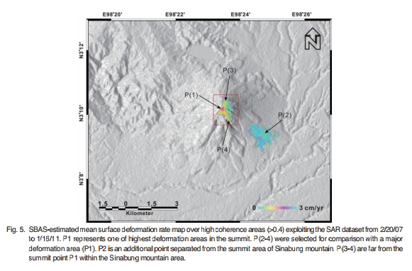
Sinabung volcano in Indonesia was formed due to the subduction between the Eurasian and Indo-Australian plates along the Pacific Ring of Fire. After being dormant for about 400 years, Sinabung volcano erupted on the 29th of August, 2010 and most recently on the 1st of November, 2016. We measured the deformation of Sinabung volcano using Advanced Land Observing Satellite/Phased Array type L-band Synthetic Aperture Radar(ALOS/PALSAR) interferometric synthetic aperture radar(InSAR) images acquired from February 2007 to January 2011. Based on multi-temporal InSAR processing, we mapped the ground surface deformation before, during, and after the 2010 eruption with time-series InSAR technique. During the 3 years before the 2010 eruption, the volcano inflated at an average rate of ~1.7 cm/yr with a markedly higher rate of 6.6 cm/yr during the 6 months prior to the 2010 eruption. The inflation was constrained to the top of the volcano. From the 2010 eruption to January 2011,the volcano subsided by approximately 3 cm (~6 cm/yr). We interpreted that the inflation was due to magma accumulation in a shallow reservoir beneath Sinabung. The deflation was attributed to magma withdrawal from the shallow reservoir during the eruption as well as thermo-elastic compaction of erupted material. This result demonstrates once again the utility of InSAR for volcano monitoring. |
|||
| 출처 | 대한원격탐사학회지 | ||
| 이전글 | 가뭄 모니터링을 위한 천리안 해양관측위성의 활용성 연구 |
|---|---|
| 다음글 | Mapping of Vegetation Using Multi-Temporal Downscaled Satellite Images of a Reclaimed Area in Saemangeum, Republic of Korea |
연관위성영상
-
 인도네시아:자미모스크 붕괴(2022-11-29)
2022-12-05
-
 필리핀:화산활동(위색영상)(2022-06-06)
2022-06-07
-
 인도네시아:Sidoarjo 진흙화산(2021-05-12)
2022-08-23
연관활용사례
-
The Impact of GC...
해양
2024-05-10
-
SSResUnet 모델을 이용...
토양
2024-04-19
-
Wildfire in Chile
재해
2024-04-04
최신미디어
-
과기정통부
국내 최초 양산형 초소형...
2024-04-26
-
과기정통부
초소형군집위성 1호 발사...
2024-04-24

네팔:지진(2015-05-05)
| 카테고리 | 재난재해 |
|---|---|
| 위성정보 | KOMPSAT-3 |
| 생성일 | 2015-03-24 |
세부정보
| ProductID | K3_20150505073608_15817_06161210 |
|---|---|
| 국가(영문) | Nepal |
| 국가 | 네팔 |
| 지역 | Pokhara |
| 레벨 | 1R |