활용사례
| 제목 | Combined use of LiDAR data and multispectral earth observation imagery for wetland habitat mapping | ||
|---|---|---|---|
| 국/내외 | 국외 | 작성일 | 2017-08-11 |
|
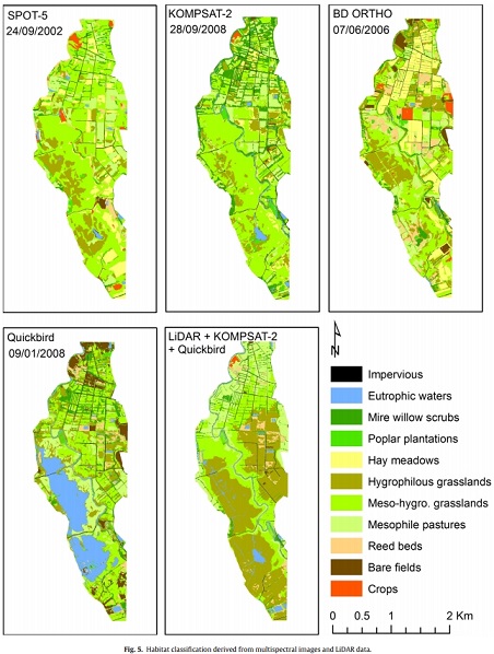
Although wetlands play a key role in controlling flooding and nonpoint source pollution, sequestering carbon and providing an abundance of ecological services, the inventory and characterization of wetland habitats are most often limited to small areas. This explains why the understanding of their ecological functioning is still insufficient for a reliable functional assessment on areas larger than a few hectares. While LiDAR data and multispectral Earth Observation (EO) images are often used separately to map wetland habitats, their combined use is currently being assessed for different habitat types. The aim of this study is to evaluate the combination of multispectral and multiseasonal imagery and LiDAR data to precisely map the distribution of wetland habitats. The image classification was performed combining an object-based approach and decision-tree modeling. Four multispectral images with high (SPOT-5) and very high spatial resolution (Quickbird, KOMPSAT-2, aerial photographs) were classified separately. Another classification was then applied integrating summer and winter multispectral image data and three layers derived from LiDAR data: vegetation height, microtopography and intensity return. The comparison of classification results shows that some habitats are better identified on the winter image and others on the summer image (overall accuracies=58.5 and 57.6%). They also point out that classification accuracy is highly improved (overall accuracy=86.5%) when combining LiDAR data and multispectral images. Moreover, this study highlights the advantage of integrating vegetation height, microtopography and intensity parameters in the classification process. This article demonstrates that information provided by the synergetic use of multispectral images and LiDAR data can help in wetland functional assessment |
|||
| 출처 | International Journal of Applied Earth Observation and Geoinformation | ||
| 이전글 | GOCI 자료를 이용한 서울 지역 고농도 미세먼지와 옅은 황사 시 에어로졸 광학적 특성 분석 |
|---|---|
| 다음글 | 도암호 유역 고랭지밭 비점오염원 관리 및 저감 방안 연구(Ⅱ) |
연관위성영상
-
 미국:자유의 여신상(2023-11-03)
2023-11-14
-
 리비아:데르나 홍수(2023-09-13)
2023-09-18
-
 스페인:홍수(2023-09-06)
2023-09-14
연관활용사례
-
SSResUnet 모델을 이용...
토양
2024-04-19
-
Wildfire in Chile
재해
2024-04-04
-
KOMPSAT-3A 영상에 대...
지리
2024-04-04
최신미디어
-
과기정통부
국내 최초 양산형 초소형...
2024-04-26
-
과기정통부
초소형군집위성 1호 발사...
2024-04-24

네팔:지진(2015-05-05)
| 카테고리 | 재난재해 |
|---|---|
| 위성정보 | KOMPSAT-3 |
| 생성일 | 2015-03-24 |
세부정보
| ProductID | K3_20150505073608_15817_06161210 |
|---|---|
| 국가(영문) | Nepal |
| 국가 | 네팔 |
| 지역 | Pokhara |
| 레벨 | 1R |