활용사례
| 제목 | Image Fusion Methods for Multispectral and Panchromatic Images of Pleiades and KOMPSAT 3 Satellites | ||
|---|---|---|---|
| 국/내외 | 국내 | 작성일 | 2018-12-07 |
|
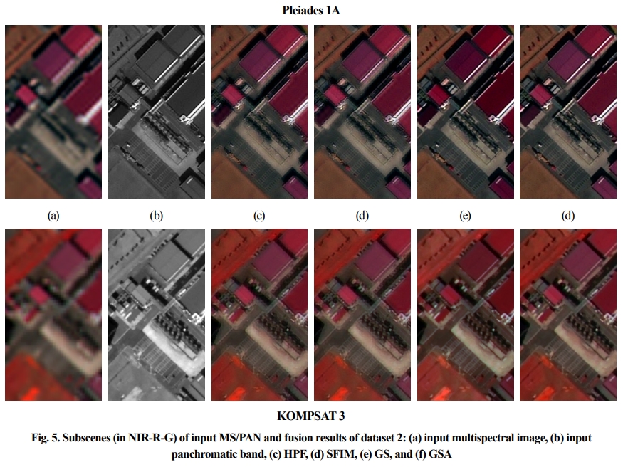
Many applications using satellite data from high-resolution multispectral sensors require an image fusion step, known as pansharpening, before processing and analyzing the multispectral images when spatial fidelity is crucial. Image fusion methods are to improve images with higher spatial and spectral resolutions by reducing spectral distortion, which occurs on image fusion processing. The image fusion methods can be classified into MRA (Multi-Resolution Analysis) and CSA (Component Substitution Analysis) approaches. To suggest the efficient image fusion method for Pleiades and KOMPSAT (Korea Multi-Purpose Satellite) 3 satellites, this study will evaluate image fusion methods for multispectral and panchromatic images. HPF (High-Pass Filtering), SFIM (Smoothing Filter-based Intensity Modulation), GS (Gram Schmidt), and GSA (Adoptive GS) were selected for MRA and CSA based image fusion methods and applied on multispectral and panchromatic images. Their performances were evaluated using visual and quality index analysis. HPF and SFIM fusion results presented low performance of spatial details. GS and GSA fusion results had enhanced spatial information closer to panchromatic images, but GS produced more spectral distortions on urban structures. This study presented that GSA was effective to improve spatial resolution of multispectral images from Pleiades 1A and KOMPSAT 3. |
|||
| 출처 | 한국측량학회지 | ||
| 이전글 | Land Masking Method for Sar-Based Ship Detection in Coastal Waters of Many Islands |
|---|---|
| 다음글 | Kompsat-3A 위성영상분류를 위한 딥러닝 적용 가능성 분석 |
연관위성영상
-
 스페인:마드리드 왕궁(2025-05-29)
2025-06-23
-
 이탈리아:Porto di Olbia(2025-05-25)
2025-06-09
-
 미국:Spokane Falls(2025-05-24)
2025-06-09
연관활용사례
-
Applicability of...
환경
2025-07-07
-
Lake detection a...
환경
2025-07-01
-
Flood in Brazil
재해
2025-06-26
연관미디어
-
항우연
누리호 3차 발사 비행정...
2023-06-26
-
항우연
누리호 3차 발사 중간 ...
2023-05-31

네팔:지진(2015-05-05)
| 카테고리 | 재난재해 |
|---|---|
| 위성정보 | KOMPSAT-3 |
| 생성일 | 2015-03-24 |
세부정보
| ProductID | K3_20150505073608_15817_06161210 |
|---|---|
| 국가(영문) | Nepal |
| 국가 | 네팔 |
| 지역 | Pokhara |
| 레벨 | 1R |