활용사례
| 제목 | Two-Dimensional Ship Velocity Estimation Based on KOMPSAT-5 Synthetic Aperture Radar Data | ||
|---|---|---|---|
| 국/내외 | 국내 | 작성일 | 2019-06-27 |
|
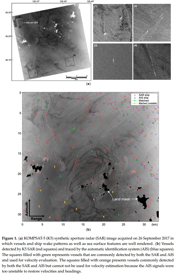
Continuously accumulating information on vessels and their activities in coastal areas of interest is important for maintaining sustainable fisheries resources and coastal ecosystems. The speed, heading, sizes, and activities of vessels in certain seasons and at certain times of day are useful information for sustainable coastal management. This paper presents a two-dimensional vessel velocity estimation method using the KOMPSAT-5 (K5) X-band synthetic aperture radar (SAR) system and Doppler parameter estimation. The estimation accuracy was evaluated by two field campaigns in 2017 and 2018. The minimum size of the vessel and signal-to-clutter ratio (SCR) for optimum estimation were determined to be 20 m and 7.7 dB, respectively. The squared correlation coefficient R2 for vessel speed and heading angle were 0.89 and 0.97, respectively, and the root-mean-square errors of the speed and heading were 1.09 m/s (2.1 knots) and 17.9°, respectively, based on 19 vessels that satisfied the criteria of minimum size of vessel and SCR. Because the K5 SAR is capable of observing a selected coastal region every day by utilizing various modes, it is feasible to accumulate a large quantity of vessel data for coastal sea for eventual use in building a coastal traffic model. |
|||
| 출처 | Remote Sensing | ||
| 이전글 | Quality Assessment of Four DEMs Generated Using In-Track KOMPSAT-3 Stereo Images |
|---|---|
| 다음글 | 광학 및 레이더 위성영상으로부터 인공신경망을 이용한 공주시 산림의 층위구조 분류 |
연관위성영상
-
 방글라데시:홍수(2022-07-04)
2022-08-08
-
 필리핀:불루산 볼케이노(2022-06-17)
2022-06-22
-
 스위스:빙하(2021-04-23)
2021-05-11
연관활용사례
-
Applicability of...
환경
2025-07-07
-
Lake detection a...
환경
2025-07-01
-
Flood in Brazil
재해
2025-06-26
최신미디어
-
과기정통부
47m 누리호, 우주의 ...
2025-05-29
-
항우연
한국항공우주연구원 홈페이...
2025-05-16

네팔:지진(2015-05-05)
| 카테고리 | 재난재해 |
|---|---|
| 위성정보 | KOMPSAT-3 |
| 생성일 | 2015-03-24 |
세부정보
| ProductID | K3_20150505073608_15817_06161210 |
|---|---|
| 국가(영문) | Nepal |
| 국가 | 네팔 |
| 지역 | Pokhara |
| 레벨 | 1R |