활용사례
| 제목 | Multi-temporal Analysis of High-resolution Satellite Images for Detecting and Monitoring Canopy Decline by Pine Pitch Canker | ||
|---|---|---|---|
| 국/내외 | 국내 | 작성일 | 2019-09-17 |
|
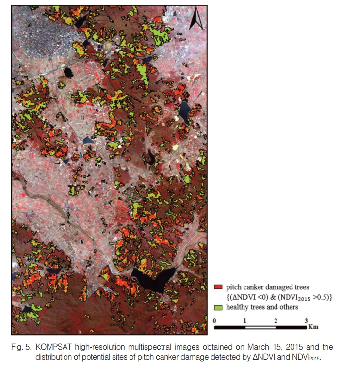
Unlike other critical forest diseases, pine pitch canker in Korea has shown rather mild symptoms of partial loss of crown foliage and leaf discoloration. This study used high-resolution satellite images to detect and monitor canopy decline by pine pitch canker. To enhance the subtle change of canopy reflectance in pitch canker damaged tree crowns, multi-temporal analysis was applied to two KOMPSAT multispectral images obtained in 2011 and 2015. To assure the spectral consistency between the two images, radiometric corrections of atmospheric and shadow effects were applied prior to multi-temporal analysis. The normalized difference vegetation index (NDVI) of each image and the NDVI difference (ΔNDVI = NDVI2015 – NDVI2011) between two images were derived. All negative ΔNDVI values were initially considered any pine stands, including both pitch canker damaged trees and other trees, that showed the decrease of crown foliage from 2011 to 2015. Next, NDVI2015 was used to exclude the canopy decline unrelated to the pitch canker damage. Field survey data were used to find the spectral characteristics of the damaged canopy and to evaluate the detection accuracy from further analysis.Although the detection accuracy as assessed by limited number of field survey on 21 sites was 71%, there were also many false alarms that were spectrally very similar to the damaged canopy. The false alarms were mostly found at the mixed stands of pine and young deciduous trees, which might invade these sites after the pine canopy had already opened by any crown damages. Using both ΔNDVI and NDVI2015 could be an effective way to narrow down the potential area of the pitch canker damage in Korea. |
|||
| 출처 | 대한원격탐사학회지 | ||
| 이전글 | 광학 및 레이더 위성영상으로부터 인공신경망을 이용한 공주시 산림의 층위구조 분류 |
|---|---|
| 다음글 | KOMPSAT과 Landsat 8을 이용한 도시확장에 따른 열환경 분석: 세종특별자치시를 중심으로 |
연관위성영상
-
 스페인:마드리드 왕궁(2025-05-29)
2025-06-23
-
 이탈리아:Porto di Olbia(2025-05-25)
2025-06-09
-
 미국:Spokane Falls(2025-05-24)
2025-06-09
연관활용사례
-
Flood in Brazil
재해
2025-06-26
-
KOMPSAT-5 영상과 RP...
지리
2025-06-23
-
Applicability of...
환경
2025-06-16
최신미디어
-
과기정통부
47m 누리호, 우주의 ...
2025-05-29
-
항우연
한국항공우주연구원 홈페이...
2025-05-16

네팔:지진(2015-05-05)
| 카테고리 | 재난재해 |
|---|---|
| 위성정보 | KOMPSAT-3 |
| 생성일 | 2015-03-24 |
세부정보
| ProductID | K3_20150505073608_15817_06161210 |
|---|---|
| 국가(영문) | Nepal |
| 국가 | 네팔 |
| 지역 | Pokhara |
| 레벨 | 1R |