활용사례
| 제목 | Topographic Information Extraction from Kompsat Satellite Stereo Data Using SGM | ||
|---|---|---|---|
| 국/내외 | 국내 | 작성일 | 2019-12-18 |
|
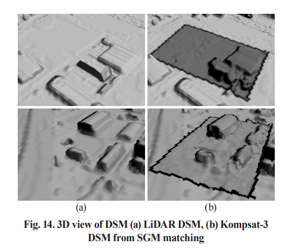
DSM (Digital Surface Model) is a digital representation of ground surface topography or terrain that is widely used for hydrology, slope analysis, and urban planning. Aerial photogrammetry and LiDAR (Light Detection And Ranging) are main technology for urban DSM generation but high-resolution satellite imagery is the only ingredient for remote inaccessible areas. Traditional automated DSM generation method is based on correlation-based methods but recent study shows that a modern pixelwise image matching method, SGM (Semi-Global Matching) can be an alternative. Therefore this study investigated the application of SGM for Kompsat satellite data of KARI (Korea Aerospace Research Institute). Firstly, the sensor modeling was carried out for precise ground-to-image computation, followed by the epipolar image resampling for efficient stereo processing. Secondly, SGM was applied using different parameterizations. The generated DSM was evaluated with a reference DSM generated by the first pulse returns of the LIDAR reference dataset. |
|||
| 출처 | 한국측량학회지 | ||
| 이전글 | Local-Based Iterative Histogram Matching for Relative Radiometric Normalization |
|---|---|
| 다음글 | 2019년 12월 필리핀 카가얀밸리 홍수 |
연관위성영상
-
 스페인:마드리드 왕궁(2025-05-29)
2025-06-23
-
 이탈리아:Porto di Olbia(2025-05-25)
2025-06-09
-
 미국:Spokane Falls(2025-05-24)
2025-06-09
연관활용사례
-
Applicability of...
환경
2025-07-07
-
Lake detection a...
환경
2025-07-01
-
KOMPSAT-5 영상과 RP...
지리
2025-06-23
최신미디어
-
과기정통부
47m 누리호, 우주의 ...
2025-05-29
-
항우연
한국항공우주연구원 홈페이...
2025-05-16

네팔:지진(2015-05-05)
| 카테고리 | 재난재해 |
|---|---|
| 위성정보 | KOMPSAT-3 |
| 생성일 | 2015-03-24 |
세부정보
| ProductID | K3_20150505073608_15817_06161210 |
|---|---|
| 국가(영문) | Nepal |
| 국가 | 네팔 |
| 지역 | Pokhara |
| 레벨 | 1R |