활용사례
| 제목 | Oil Spill Mapping from Kompsat-2 High-Resolution Image Using Directional Median Filtering and Artificial Neural Network | ||
|---|---|---|---|
| 국/내외 | 국외 | 작성일 | 2020-02-10 |
|
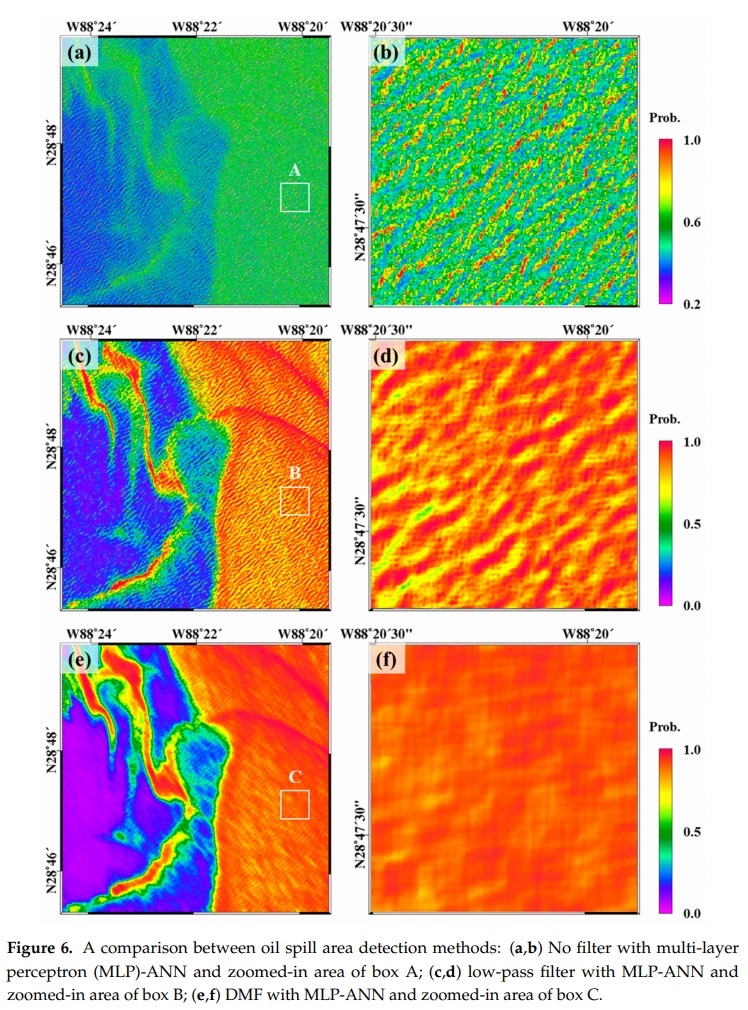
Oil spill accidents in marine environments have a massive impact on ecosystems. Various methods have been developed to detect oil spills using high-resolution optical imagery. However, ocean waves caused by heavy winds occurring in the accident area cause sun glint in the image, and this severely impedes the ability to detect the oil spill area. The objective of this study was to detect oil spill areas from high-resolution optic images using the artificial neural network (ANN) through effective suppression of severe sun glint effects. To enable this, a directional median filter (DMF) was adapted, and its use was compared with that of a traditional low-pass filter. A performance test was conducted using a KOMPSAT-2 image acquired during oil spill accidents that occurred in the Gulf of Mexico in 2010. The proposed method involved two main steps: (i) The sun glint effects caused by the ocean waves were corrected using the DMF; and (ii) the ANN approach was used to detect the oil spill area. The results show the following: (i) The designed DMF, which considers the size and angle of ocean waves, was proficient in correcting the sun glint effect in a high-resolution optical image; and (ii) oil spill areas were efficiently detected using the ANN approach with the proposed filtering method. The oil spill area was classified with accuracies of approximately 98.12% and 89.56% using the receiver operating characteristic (ROC) curve and probability of detection (POD) measurements, respectively. These results show that the accuracy of the proposed method is improved by about 9% compared to the traditional detecting algorithm. |
|||
| 출처 | Remote Sensing | ||
| 이전글 | KOMPSAT-5 위성 영상을 활용한 라오스 세피안-세남노이 댐 붕괴에 따른 수계변화 탐지 |
|---|---|
| 다음글 | Detection of Wildfire-Damaged Areas Using Kompsat-3: Image A Case of the 2019 Unbong Mountain Fire in Busan, South Korea |
연관위성영상
-
 미국:컨강 유전(2022-01-30)
2022-11-24
-
 미국:Red Salmon Complex Fire(위색)(2020-09-08)
2020-09-16
-
 러시아:노릴스크 기름 유출(2020-06-08)
2020-06-25
연관활용사례
-
항공영상을 이용한 다목적실용위...
지리
2024-04-24
-
SSResUnet 모델을 이용...
토양
2024-04-19
-
Wildfire in Chile
재해
2024-04-04
최신미디어
-
과기정통부
국내 최초 양산형 초소형...
2024-04-26
-
과기정통부
초소형군집위성 1호 발사...
2024-04-24

네팔:지진(2015-05-05)
| 카테고리 | 재난재해 |
|---|---|
| 위성정보 | KOMPSAT-3 |
| 생성일 | 2015-03-24 |
세부정보
| ProductID | K3_20150505073608_15817_06161210 |
|---|---|
| 국가(영문) | Nepal |
| 국가 | 네팔 |
| 지역 | Pokhara |
| 레벨 | 1R |