활용사례
| 제목 | 정지궤도 위성의 적외선 채널 관측을 이용한 산불과 스모크 동시 모니터링 | ||
|---|---|---|---|
| 국/내외 | 국내 | 작성일 | 2024-07-15 |
|
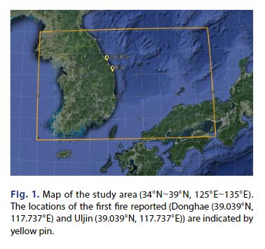
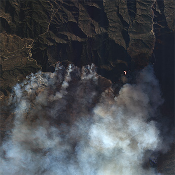
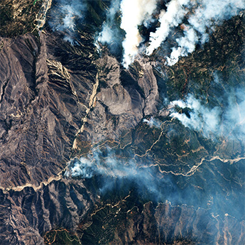
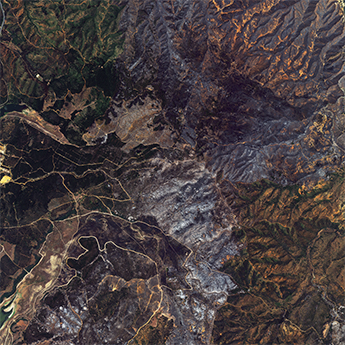
Large wildfires have a significant impact on regional air quality and climate. Active fires and smoke emissions are highly variable, making it difficult to determine their impact on air quality. In this study, we present a methodology to derive temporal location information on active fire and smoke using observations from the Advanced Meteorological Imager (AMI) on Geo-KOMPSAT-2A (GK2A). Comparison of the GK2A/AMI obser vations with Moderate Resolution Imaging Spectroradiometer (MODIS) fire products confirmed that the location of active fires and the area of smoke plumes were well detected within the observation coverage. In March 2022, two large wildfires in eastern South Korea burned an area of more than 250 square kilometers and sent huge smoke plumes up to 20 kilometers over the East Sea, resulting in PM10 and PM2.5 concentrations of up to 910 μg/m3 and 803 μg/m3, respectively, measured at the nearest stations. Therefore, integrated analysis of ground-based and remote sensing observations can play an important role in effectively monitoring wildfire areas and smoke plumes. |
|||
| 출처 | 한국대기환경학회 | ||
| 이전글 | KOMPSAT-3/3A호 영상 기반 선박탐지 인공지능 학습 데이터셋 |
|---|---|
| 다음글 | 정지궤도 공공복합통신 위성의 태양 전지판 구동기 운영를 위한 연구 |
연관위성영상
-
 미국:LA 산불(2025-01-09)
2025-01-31
-
 미국:하일랜드 산불(2024-09-14)
2024-09-26
-
 칠레:칠레 발파라조 산불(2024-02-06)
2024-05-21
연관활용사례
-
고해상도 위성 데이터 기하보정...
지리
2025-04-16
-
KOMPSAT-3/3A 위성...
지리
2025-04-10
-
중복 딥러닝 모델을 이용한 K...
토양
2025-02-13
연관미디어
-
보도자료
시작도 전에 "돈 더 달...
2025-06-27
-
항우연
누리호 5차 발사 부탑재...
2024-12-16
-
항우연
누리호 2차 발사 성능검...
2024-08-14

네팔:지진(2015-05-05)
| 카테고리 | 재난재해 |
|---|---|
| 위성정보 | KOMPSAT-3 |
| 생성일 | 2015-03-24 |
세부정보
| ProductID | K3_20150505073608_15817_06161210 |
|---|---|
| 국가(영문) | Nepal |
| 국가 | 네팔 |
| 지역 | Pokhara |
| 레벨 | 1R |