활용사례
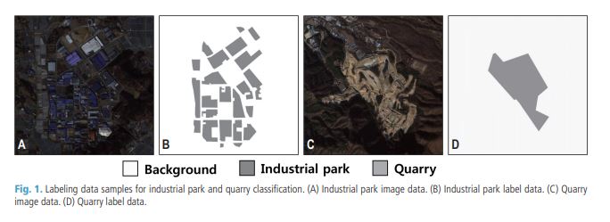
| 제목 | KOMPSAT-3/3A 광학 위성영상으로부터 산업단지 및 채석장 분류를 위한 GeoAI 데이터셋 | ||
|---|---|---|---|
| 국/내외 | 국내 | 작성일 | 2024-07-22 |
|
Air pollution is a serious problem in the world, and it is necessary to monitor air pollution emission sources in other neighboring countries to respond to the problem of air pollution spreading across borders. In this study, we utilized domestic and international optical images from KOMPSAT-3/3A satellites to build an AI training dataset for classifying industrial parks and quarries, which are representative sources of air pollution emissions. The data can be used to identify the distribution of air pollution emission sources located at home and abroad along with various state-ofthe-art models in the image segmentation field, and is expected to contribute to the preservation of Korea’s air environment as a basis for establishing air-related policies. |
|||
| 출처 | GEO DATA | ||
| 이전글 | KOMPSAT-3와 KOMPSAT-5 SAR 영상을 이용한 토양수분 산정과 결과 검증: 제주 서부지역 사례 연구 |
|---|---|
| 다음글 | 아리랑 5호 위성 영상에서 수계의 의미론적분할을 위한 딥러닝 모델의 비교 연구 |
연관위성영상
-
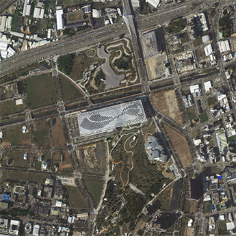 대만:전시관 및 무역센터(2025-01-23)
2025-02-26
-
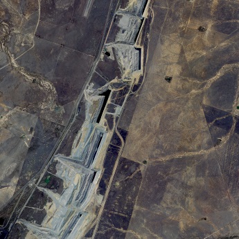 오스트레일리아:석탄 채석장(2020-09-27)
2021-04-13
연관활용사례
-
고해상도 위성 데이터 기하보정...
지리
2025-04-16
-
KOMPSAT-3/3A 위성...
지리
2025-04-10
-
중복 딥러닝 모델을 이용한 K...
토양
2025-02-13
연관미디어
-
항우연
다누리, 연장 임무 궤도...
2025-02-21
-
항우연
누리호 4차 발사를 위한...
2024-07-09

네팔:지진(2015-05-05)
| 카테고리 | 재난재해 |
|---|---|
| 위성정보 | KOMPSAT-3 |
| 생성일 | 2015-03-24 |
세부정보
| ProductID | K3_20150505073608_15817_06161210 |
|---|---|
| 국가(영문) | Nepal |
| 국가 | 네팔 |
| 지역 | Pokhara |
| 레벨 | 1R |