활용사례
| 제목 | SATELLITE IMAGES OF ASIAN DISASTER | ||
|---|---|---|---|
| 국/내외 | 국외 | 작성일 | 2015-03-23 |
|
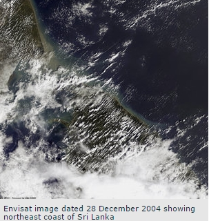
Since the disaster struck, three authorised users of the International Charter on Space and Major Disasters have requested its support from the on-duty operator at ESA/ESRIN. Satellite images of the disaster areas taken before and after the tsunami have been supplied to the UN Office of Outer Space Affairs, the French Civil Protection and the Indian Space Research Organisation. |
|||
| 출처 | http://www.esa.int/ | ||
| 이전글 | 광역의 가뭄 분석을 위한 위성영상의 활용 |
|---|---|
| 다음글 | Satellite images used to aid disaster relief |
연관위성영상
-
 오스트리아:UPC 아레나(2024-02-08)
2024-05-21
-
 미국:매직킹덤파크(2024-02-07)
2024-05-21
-
 칠레:칠레 발파라조 산불(2024-02-06)
2024-05-21
연관활용사례
-
다목적실용위성 3A 영상정보의...
지리
2024-05-13
-
The Impact of GC...
해양
2024-05-10
-
SSResUnet 모델을 이용...
토양
2024-04-19
최신미디어
-
과기정통부
국내 최초 양산형 초소형...
2024-04-26
-
과기정통부
초소형군집위성 1호 발사...
2024-04-24

네팔:지진(2015-05-05)
| 카테고리 | 재난재해 |
|---|---|
| 위성정보 | KOMPSAT-3 |
| 생성일 | 2015-03-24 |
세부정보
| ProductID | K3_20150505073608_15817_06161210 |
|---|---|
| 국가(영문) | Nepal |
| 국가 | 네팔 |
| 지역 | Pokhara |
| 레벨 | 1R |