활용사례
| 제목 | 서해연안 토지이용 및 토지피복 변화탐지를 위한 KOMPSAT-2 영상의 활용 | ||
|---|---|---|---|
| 국/내외 | 국내 | 작성일 | 2016-10-06 |
|
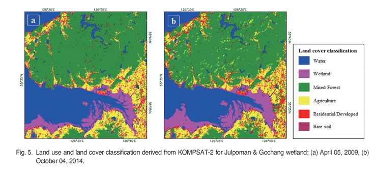
Reliable assessment of Land Use and Land Cover (LULC) changes greatly improves many practical issues in hydrography, socio-geographical research such as the observation of erosion and accretion, coastal monitoring, ecological effects evaluation. Remote sensing imageries can offer the outstanding capability to monitor nature and extent of land and associated changes over time. Nowadays accurate analysis using remote sensing imageries with high spatio-temporal resolution is required for environmental monitoring. Thisstudy develops a methodology of mapping and change detection in LULC by using classified Korea Multi-Purpose Satellite-2 (KOMPSAT-2) multispectral imageries at Jeonbuk and Jeonnam provincesincluding protected tidal flatslocated in the west coasts of Korean peninsula from 2008 to 2015. The LULC maps generated from unsupervised classification were analyzed and evaluated by post-classification change detection methods. The LULC assessment in Jeonbuk and Jeonnam areas had not showed significant changes over time although developed area was gradually increased only by 1.97% and 4.34% at both areas respectively. Overall, the results of this study quantify the land cover change patternsthrough pixel based analysis which demonstrate the potential of multispectral KOMPSAT-2 images to provide effective and economical LULC maps in the coastal zone over time. This LULC information would be of great interest to the environmental and policy mangers for the better coastal management and political decisions. |
|||
| 출처 | 대한원격탐사학회지(KoreaScience 제공) | ||
| 이전글 | Landsat 위성영상에 의한 용도지역 온도변화분석 |
|---|---|
| 다음글 | 위성영상을 이용한 대청호 남조류의 공간 분포 맵핑 |
연관위성영상
-
 스페인:화재(위색영상)(2023-08-19)
2023-08-25
-
 탄자니아:화재(위색영상)(2023-07-09)
2023-08-08
-
 캐나다:화재(위색영상)(2023-07-07)
2023-08-08
연관활용사례
-
다목적실용위성 3A 영상정보의...
지리
2024-05-13
-
KOMSPAT-3 광학 영상과...
토양
2024-05-10
-
항공영상을 이용한 다목적실용위...
지리
2024-04-24
연관미디어
-
항우연
항우연, 심우주탐사를 위...
2024-03-14
-
항우연
다누리 발사 1주년 기념...
2023-08-08

네팔:지진(2015-05-05)
| 카테고리 | 재난재해 |
|---|---|
| 위성정보 | KOMPSAT-3 |
| 생성일 | 2015-03-24 |
세부정보
| ProductID | K3_20150505073608_15817_06161210 |
|---|---|
| 국가(영문) | Nepal |
| 국가 | 네팔 |
| 지역 | Pokhara |
| 레벨 | 1R |