활용사례
| 제목 | International Charter: Earthquake and eruption of Kilauea Volcano in the United States | ||
|---|---|---|---|
| 국/내외 | 국외 | 작성일 | 2018-05-23 |
|
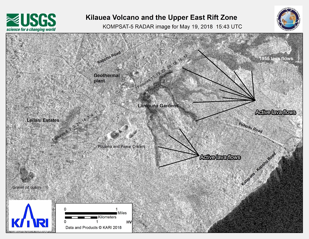
Kilauea Volcano in Hawaii erupted on 4 May, and the island also experienced a magnitude 6.9 earthquake on the same day. 2000 people have been evacuated from the area and hundreds of homes in the path of the eruption are at risk, but no casualties have been reported. |
|||
| 출처 | International Charter | ||
| 이전글 | 위성정보를 활용한 해양 기름유출 탐지 알고리즘 기술 개발 |
|---|---|
| 다음글 | 국토위성정보 활용을 위한 주요 활용·응용기술 개발 |
연관위성영상
-
 아랍에미리트:Al Qurm Beach(2025-04-01)
2025-05-27
-
 스웨덴:The Royal Palace(2025-03-19)
2025-06-09
-
 미국:LA 산불(2025-01-09)
2025-01-31
연관활용사례
-
Lake detection a...
환경
2025-07-01
-
Flood in Brazil
재해
2025-06-26
-
KOMPSAT-5 영상과 RP...
지리
2025-06-23
최신미디어
-
과기정통부
47m 누리호, 우주의 ...
2025-05-29
-
항우연
한국항공우주연구원 홈페이...
2025-05-16

네팔:지진(2015-05-05)
| 카테고리 | 재난재해 |
|---|---|
| 위성정보 | KOMPSAT-3 |
| 생성일 | 2015-03-24 |
세부정보
| ProductID | K3_20150505073608_15817_06161210 |
|---|---|
| 국가(영문) | Nepal |
| 국가 | 네팔 |
| 지역 | Pokhara |
| 레벨 | 1R |