활용사례
| 제목 | Comparison of Pre-Event VHR Optical Data and Post-Event PolSAR Data to Investigate Damage Caused by the 2011 Japan Tsunami in Built-Up Areas | ||
|---|---|---|---|
| 국/내외 | 국외 | 작성일 | 2019-03-15 |
|
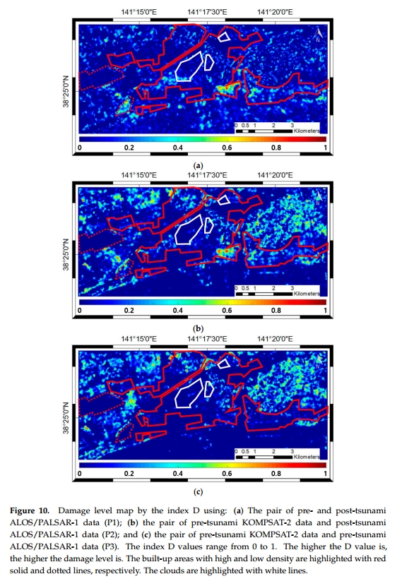
Combining pre-disaster optical and post-disaster synthetic aperture radar (SAR) satellite data is essential for the timely damage investigation because the availability of data in a disaster area is usually limited. This article proposes a novel method to assess damage in urban areas by analyzing combined pre-disaster very high resolution (VHR) optical data and post-disaster polarimetric SAR (PolSAR) data, which has rarely been used in previous research because the two data have extremely different characteristics. To overcome these differences and effectively compare VHR optical data and PolSAR data, a technique to simulate polarization orientation angles (POAs) in built-up areas was developed using building orientations extracted from VHR optical data. The POA is an intrinsic parameter of PolSAR data and has a physical relationship with building orientation. A damage level indicator was also proposed, based on the consideration of diminished homogeneity of POA values by damaged buildings. The indicator is the difference between directional dispersions of the pre and post-disaster POA values. Damage assessment in urban areas was conducted by using the indicator calculated with the simulated pre-disaster POAs from VHR optical data and the derived post-disaster PolSAR POAs. The proposed method was validated on the case study of the 2011 tsunami in Japan using pre-disaster KOMPSAT-2 data and post-disaster ALOS/PALSAR-1 data. The experimental results demonstrated that the proposed method accurately simulated the POAs with a root mean square error (RMSE) value of 2.761° and successfully measured the level of damage in built-up areas. The proposed method can facilitate efficient and fast damage assessment in built-up areas by comparing pre-disaster VHR optical data and post-disaster PolSAR data. |
|||
| 출처 | Remote Sensing | ||
| 이전글 | KOMPSAT-5 후방산란계수 자료로 산출된 해상풍 검증 |
|---|---|
| 다음글 | Pansharpening Using Guided Filtering to Improve the Spatial Clarity of VHR Satellite Imagery |
연관위성영상
-
 사우디아라비아:더 라인(2023-02-18)
2023-08-25
-
 일본:도쿄(2023-02-09)
2023-04-07
-
 그리스 공화국:산토리니 섬(2022-11-24)
2022-12-05
연관활용사례
-
SSResUnet 모델을 이용...
토양
2024-04-19
-
Wildfire in Chile
재해
2024-04-04
-
고해상도 위성 데이터 처리를 ...
지리
2024-03-15
최신미디어
-
과기정통부
국내 최초 양산형 초소형...
2024-04-26
-
과기정통부
초소형군집위성 1호 발사...
2024-04-24

네팔:지진(2015-05-05)
| 카테고리 | 재난재해 |
|---|---|
| 위성정보 | KOMPSAT-3 |
| 생성일 | 2015-03-24 |
세부정보
| ProductID | K3_20150505073608_15817_06161210 |
|---|---|
| 국가(영문) | Nepal |
| 국가 | 네팔 |
| 지역 | Pokhara |
| 레벨 | 1R |