활용사례
| 제목 | Pansharpening Using Guided Filtering to Improve the Spatial Clarity of VHR Satellite Imagery | ||
|---|---|---|---|
| 국/내외 | 국내 | 작성일 | 2019-03-26 |
|
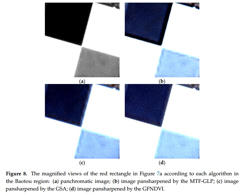
Pansharpening algorithms are designed to enhance the spatial resolution of multispectral images using panchromatic images with high spatial resolutions. Panchromatic and multispectral images acquired from very high resolution (VHR) satellite sensors used as input data in the pansharpening process are characterized by spatial dissimilarities due to differences in their spectral/spatial characteristics and time lags between panchromatic and multispectral sensors. In this manuscript, a new pansharpening framework is proposed to improve the spatial clarity of VHR satellite imagery. This algorithm aims to remove the spatial dissimilarity between panchromatic and multispectral images using guided filtering (GF) and to generate the optimal local injection gains for pansharpening. First, we generate optimal multispectral images with spatial characteristics similar to those of panchromatic images using GF. Then, multiresolution analysis (MRA)-based pansharpening is applied using normalized difference vegetation index (NDVI)-based optimal injection gains and spatial details obtained through GF. The algorithm is applied to Korea multipurpose satellite (KOMPSAT)-3/3A satellite sensor data, and the experimental results show that the pansharpened images obtained with the proposed algorithm exhibit a superior spatial quality and preserve spectral information better than those based on existing algorithms. |
|||
| 출처 | Remote Sensing | ||
| 이전글 | Comparison of Pre-Event VHR Optical Data and Post-Event PolSAR Data to Investigate Damage Caused by the 2011 Japan Tsunami in Built-Up Areas |
|---|---|
| 다음글 | 위성영상을 이용한 국공유지 변화 탐지 연구 |
연관위성영상
-
 미국:자유의 여신상(2023-11-03)
2023-11-14
-
 리비아:데르나 홍수(2023-09-13)
2023-09-18
-
 스페인:홍수(2023-09-06)
2023-09-14
연관활용사례
-
SSResUnet 모델을 이용...
토양
2024-04-19
-
Wildfire in Chile
재해
2024-04-04
-
KOMPSAT-3A 영상에 대...
지리
2024-04-04
최신미디어
-
과기정통부
국내 최초 양산형 초소형...
2024-04-26
-
과기정통부
초소형군집위성 1호 발사...
2024-04-24

네팔:지진(2015-05-05)
| 카테고리 | 재난재해 |
|---|---|
| 위성정보 | KOMPSAT-3 |
| 생성일 | 2015-03-24 |
세부정보
| ProductID | K3_20150505073608_15817_06161210 |
|---|---|
| 국가(영문) | Nepal |
| 국가 | 네팔 |
| 지역 | Pokhara |
| 레벨 | 1R |