활용사례
| 제목 | Rigorous Co-Registration of KOMPSAT-3 Multispectral and Panchromatic Images for Pan-Sharpening Image Fusion | ||
|---|---|---|---|
| 국/내외 | 국내 | 작성일 | 2020-04-16 |
|
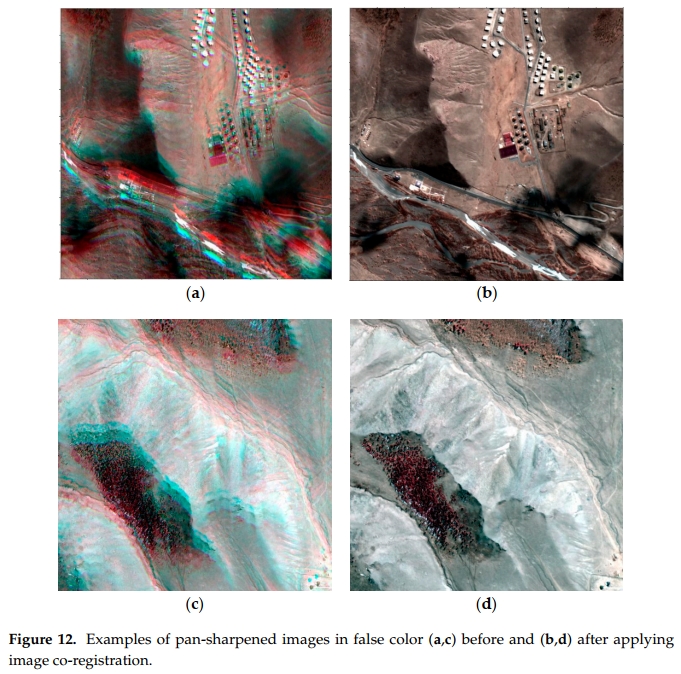
KOMPSAT-3, a Korean earth observing satellite, provides the panchromatic (PAN) band and four multispectral (MS) bands. They can be fused to obtain a pan-sharpened image of higher resolution in both the spectral and spatial domain, which is more informative and interpretative for visual inspection. In KOMPSAT-3 Advanced Earth Imaging Sensor System (AEISS) uni-focal camera system, the precise sensor alignment is a prerequisite for the fusion of MS and PAN images because MS and PAN Charge-Coupled Device (CCD) sensors are installed with certain offsets. In addition, exterior effects associated with the ephemeris and terrain elevation lead to the geometric discrepancy between MS and PAN images. Therefore, we propose a rigorous co-registration of KOMPSAT-3 MS and PAN images based on physical sensor modeling. We evaluated the impacts of CCD line offsets, ephemeris, and terrain elevation on the difference in image coordinates. The analysis enables precise co-registration modeling between MS and PAN images. An experiment with KOMPSAT-3 images produced negligible geometric discrepancy between MS and PAN images. |
|||
| 출처 | Sensors | ||
| 이전글 | 바누아투 루간빌 지역의 열대 저기압 해럴드 전후 영상 |
|---|---|
| 다음글 | 우주에서 바라본 코로나 19 이후 '텅 비어버린' 지구촌 |
연관위성영상
-
 미국:자유의 여신상(2023-11-03)
2023-11-14
-
 리비아:데르나 홍수(2023-09-13)
2023-09-18
-
 스페인:홍수(2023-09-06)
2023-09-14
연관활용사례
-
KOMPSAT-3/3A 영상으...
토양
2024-04-19
-
SSResUnet 모델을 이용...
토양
2024-04-19
-
KOMPSAT-3/3A 영상으...
환경
2024-04-16
최신미디어
-
과기정통부
국내 최초 양산형 초소형...
2024-04-26
-
과기정통부
초소형군집위성 1호 발사...
2024-04-24

네팔:지진(2015-05-05)
| 카테고리 | 재난재해 |
|---|---|
| 위성정보 | KOMPSAT-3 |
| 생성일 | 2015-03-24 |
세부정보
| ProductID | K3_20150505073608_15817_06161210 |
|---|---|
| 국가(영문) | Nepal |
| 국가 | 네팔 |
| 지역 | Pokhara |
| 레벨 | 1R |